You are here: Home > Network List > II - Global Seismograph Network (GSN - IRIS/IDA) Stations List
> Station MBAR Mbarara, Uganda > Earthquake Result Viewer
MBAR Mbarara, Uganda - Earthquake Result Viewer
| Earthquake location: |
Turkey |
| Earthquake latitude/longitude: |
38.6/30.9 |
| Earthquake time(UTC): |
2002/02/03 (034) 09:26:43 GMT |
| Earthquake Depth: |
10 km |
| Earthquake Magnitude: |
5.7 MB, 5.6 MS, 6.0 MW, 5.8 MW |
| Earthquake Catalog/Contributor: |
WHDF/NEIC |
|
| Network: |
II Global Seismograph Network (GSN - IRIS/IDA) |
| Station: |
MBAR Mbarara, Uganda |
| Lat/Lon: |
0.60 S/30.74 E |
| Elevation: |
1390 m |
|
| Distance: |
39.0 deg |
| Az: |
180.26 deg |
| Baz: |
0.204 deg |
| Ray Param: |
0.07521264 |
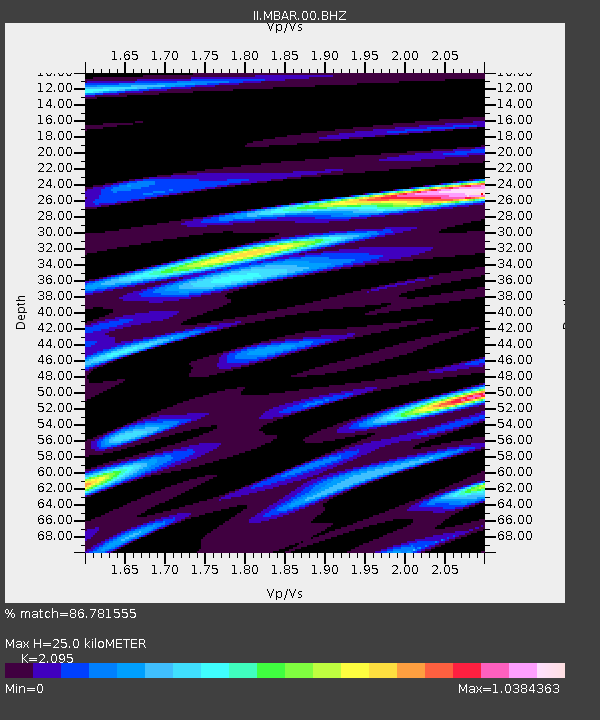
| Estimated Moho Depth: |
25.0 km |
| Estimated Crust Vp/Vs: |
2.10 |
| Assumed Crust Vp: |
6.419 km/s |
| Estimated Crust Vs: |
3.064 km/s |
| Estimated Crust Poisson's Ratio: |
0.35 |
|
| Radial Match: |
86.781555 % |
| Radial Bump: |
400 |
| Transverse Match: |
68.54397 % |
| Transverse Bump: |
400 |
| SOD ConfigId: |
590571 |
| Insert Time: |
2013-09-24 22:18:43.377 +0000 |
| GWidth: |
2.5 |
| Max Bumps: |
400 |
| Tol: |
0.001 |
|

Signal To Noise
| Channel | StoN | STA | LTA |
| II:MBAR:00:BHZ:20020203T09:33:39.353998Z | 5.368456 | 4.0466585E-7 | 7.537845E-8 |
| II:MBAR:00:BH1:20020203T09:33:39.353998Z | 6.083137 | 2.3569832E-7 | 3.874618E-8 |
| II:MBAR:00:BH2:20020203T09:33:39.353998Z | 2.7223814 | 1.3056064E-7 | 4.7958245E-8 |
| Arrivals |
| Ps | 4.5 SECOND |
| PpPs | 11 SECOND |
| PsPs/PpSs | 16 SECOND |


