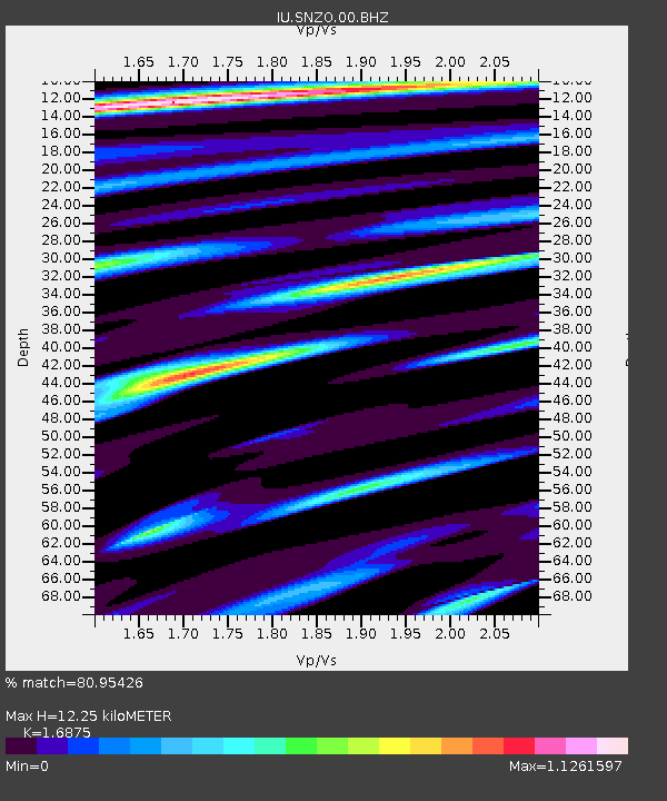
SNZO South Karori, New Zealand - Earthquake Result Viewer
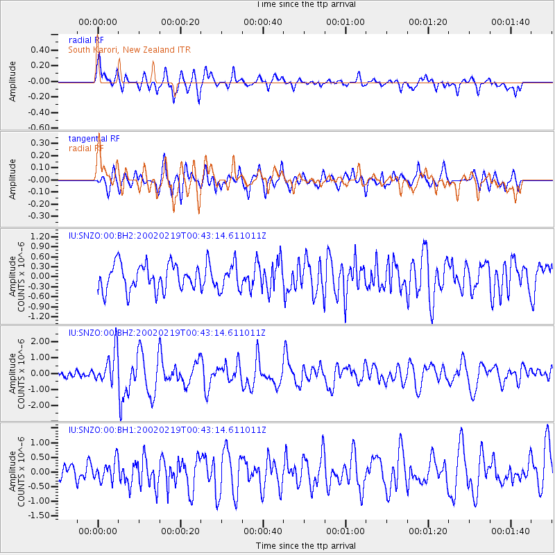
Earthquake location: New Ireland Region, P.N.G.
Earthquake latitude/longitude: -3.7/151.0
Earthquake time(UTC): 2002/02/19 (050) 00:35:45 GMT
Earthquake Depth: 10 km
Earthquake Magnitude: 5.9 MB, 6.0 MS, 6.1 MW, 6.1 MW
Earthquake Catalog/Contributor: WHDF/NEIC
Network: IU Global Seismograph Network (GSN - IRIS/USGS)
Station: SNZO South Karori, New Zealand
Lat/Lon: 41.31 S/174.70 E
Elevation: 62 m
Distance: 43.0 deg
Az: 153.651 deg
Baz: 323.99 deg
Ray Param: 0.07280352
Estimated Moho Depth: 12.25 km
Estimated Crust Vp/Vs: 1.69
Assumed Crust Vp: 6.461 km/s
Estimated Crust Vs: 3.829 km/s
Estimated Crust Poisson's Ratio: 0.23
Radial Match: 80.95426 %
Radial Bump: 400
Transverse Match: 55.7833 %
Transverse Bump: 400
SOD ConfigId: 590571
Insert Time: 2013-09-24 22:23:04.141 +0000
GWidth: 2.5
Max Bumps: 400
Tol: 0.001

Signal To Noise

ChannelStoNSTALTA
IU:SNZO:00:BHZ:20020219T00:43:14.611011Z3.19488721.076573E-63.3696745E-7
IU:SNZO:00:BH1:20020219T00:43:14.611011Z1.21283653.506606E-72.891244E-7
IU:SNZO:00:BH2:20020219T00:43:14.611011Z1.02466753.9247848E-73.8303008E-7
Arrivals
Ps1.4 SECOND
PpPs4.7 SECOND
PsPs/PpSs6.1 SECOND