You are here: Home > Network List > IU - Global Seismograph Network (GSN - IRIS/USGS) Stations List
> Station RSSD Black Hills, South Dakota, USA > Earthquake Result Viewer
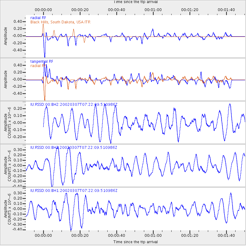
RSSD Black Hills, South Dakota, USA - Earthquake Result Viewer
*The percent match for this event was below the threshold and hence no stack was calculated.
| Earthquake location: |
Central Mid-Atlantic Ridge |
| Earthquake latitude/longitude: |
-1.3/-24.5 |
| Earthquake time(UTC): |
2002/03/07 (066) 07:10:13 GMT |
| Earthquake Depth: |
10 km |
| Earthquake Magnitude: |
5.6 MW |
| Earthquake Catalog/Contributor: |
NEIC PDE/NEIC PDE-M |
|
| Network: |
IU Global Seismograph Network (GSN - IRIS/USGS) |
| Station: |
RSSD Black Hills, South Dakota, USA |
| Lat/Lon: |
44.12 N/104.04 W |
| Elevation: |
2060 m |
|
| Distance: |
83.4 deg |
| Az: |
314.522 deg |
| Baz: |
98.23 deg |
| Ray Param: |
$rayparam |
*The percent match for this event was below the threshold and hence was not used in the summary stack. |
|
| Radial Match: |
54.31664 % |
| Radial Bump: |
400 |
| Transverse Match: |
55.662254 % |
| Transverse Bump: |
391 |
| SOD ConfigId: |
590571 |
| Insert Time: |
2013-09-24 22:28:16.072 +0000 |
| GWidth: |
2.5 |
| Max Bumps: |
400 |
| Tol: |
0.001 |
|
Signal To Noise
| Channel | StoN | STA | LTA |
| IU:RSSD:00:BHZ:20020307T07:22:09.510986Z | 2.1729648 | 1.6452306E-7 | 7.5713636E-8 |
| IU:RSSD:00:BH1:20020307T07:22:09.510986Z | 0.6009122 | 7.902667E-8 | 1.3151117E-7 |
| IU:RSSD:00:BH2:20020307T07:22:09.510986Z | 1.5847453 | 1.8368554E-7 | 1.1590857E-7 |
| Arrivals |
| Ps | |
| PpPs | |
| PsPs/PpSs | |


