You are here: Home > Network List > II - Global Seismograph Network (GSN - IRIS/IDA) Stations List
> Station PALK Pallekele, Sri Lanka > Earthquake Result Viewer
PALK Pallekele, Sri Lanka - Earthquake Result Viewer
| Earthquake location: |
Minahassa Peninsula, Sulawesi |
| Earthquake latitude/longitude: |
0.7/122.3 |
| Earthquake time(UTC): |
2002/03/17 (076) 03:37:19 GMT |
| Earthquake Depth: |
79 km |
| Earthquake Magnitude: |
5.6 MB, 5.8 MW, 5.7 MW |
| Earthquake Catalog/Contributor: |
WHDF/NEIC |
|
| Network: |
II Global Seismograph Network (GSN - IRIS/IDA) |
| Station: |
PALK Pallekele, Sri Lanka |
| Lat/Lon: |
7.27 N/80.70 E |
| Elevation: |
460 m |
|
| Distance: |
42.0 deg |
| Az: |
280.07 deg |
| Baz: |
97.066 deg |
| Ray Param: |
0.07318595 |
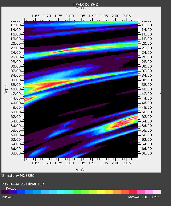
| Estimated Moho Depth: |
44.25 km |
| Estimated Crust Vp/Vs: |
1.60 |
| Assumed Crust Vp: |
6.545 km/s |
| Estimated Crust Vs: |
4.091 km/s |
| Estimated Crust Poisson's Ratio: |
0.18 |
|
| Radial Match: |
90.8899 % |
| Radial Bump: |
323 |
| Transverse Match: |
77.118286 % |
| Transverse Bump: |
400 |
| SOD ConfigId: |
590571 |
| Insert Time: |
2013-09-24 22:31:40.272 +0000 |
| GWidth: |
2.5 |
| Max Bumps: |
400 |
| Tol: |
0.001 |
|
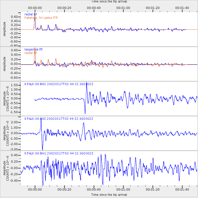
Signal To Noise
| Channel | StoN | STA | LTA |
| II:PALK:00:BHZ:20020317T03:44:32.992002Z | 12.495861 | 7.901385E-7 | 6.3232015E-8 |
| II:PALK:00:BH1:20020317T03:44:32.992002Z | 1.1891569 | 8.6305306E-8 | 7.257689E-8 |
| II:PALK:00:BH2:20020317T03:44:32.992002Z | 7.128735 | 4.402101E-7 | 6.17515E-8 |
| Arrivals |
| Ps | 4.4 SECOND |
| PpPs | 16 SECOND |
| PsPs/PpSs | 21 SECOND |


