You are here: Home > Network List > IU - Global Seismograph Network (GSN - IRIS/USGS) Stations List
> Station RSSD Black Hills, South Dakota, USA > Earthquake Result Viewer
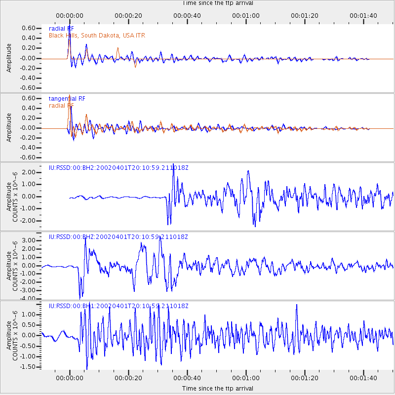
RSSD Black Hills, South Dakota, USA - Earthquake Result Viewer
*The percent match for this event was below the threshold and hence no stack was calculated.
| Earthquake location: |
Near Coast Of Central Chile |
| Earthquake latitude/longitude: |
-29.7/-71.4 |
| Earthquake time(UTC): |
2002/04/01 (091) 19:59:32 GMT |
| Earthquake Depth: |
71 km |
| Earthquake Magnitude: |
6.1 MB, 6.4 MW, 6.4 MW |
| Earthquake Catalog/Contributor: |
WHDF/NEIC |
|
| Network: |
IU Global Seismograph Network (GSN - IRIS/USGS) |
| Station: |
RSSD Black Hills, South Dakota, USA |
| Lat/Lon: |
44.12 N/104.04 W |
| Elevation: |
2060 m |
|
| Distance: |
79.3 deg |
| Az: |
336.704 deg |
| Baz: |
151.451 deg |
| Ray Param: |
$rayparam |
*The percent match for this event was below the threshold and hence was not used in the summary stack. |
|
| Radial Match: |
96.64336 % |
| Radial Bump: |
400 |
| Transverse Match: |
89.68541 % |
| Transverse Bump: |
400 |
| SOD ConfigId: |
590571 |
| Insert Time: |
2013-09-24 22:40:32.920 +0000 |
| GWidth: |
2.5 |
| Max Bumps: |
400 |
| Tol: |
0.001 |
|
Signal To Noise
| Channel | StoN | STA | LTA |
| IU:RSSD:00:BHZ:20020401T20:10:59.211018Z | 14.436695 | 1.5393852E-6 | 1.06630026E-7 |
| IU:RSSD:00:BH1:20020401T20:10:59.211018Z | 3.5776134 | 3.53796E-7 | 9.8891626E-8 |
| IU:RSSD:00:BH2:20020401T20:10:59.211018Z | 12.152148 | 7.815058E-7 | 6.431009E-8 |
| Arrivals |
| Ps | |
| PpPs | |
| PsPs/PpSs | |


