You are here: Home > Network List > IU - Global Seismograph Network (GSN - IRIS/USGS) Stations List
> Station POHA Pohakuloa, Hawaii, USA > Earthquake Result Viewer
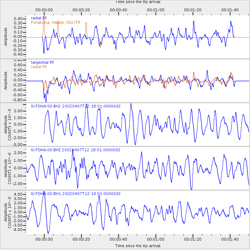
POHA Pohakuloa, Hawaii, USA - Earthquake Result Viewer
*The percent match for this event was below the threshold and hence no stack was calculated.
| Earthquake location: |
Santa Cruz Islands Region |
| Earthquake latitude/longitude: |
-10.8/164.2 |
| Earthquake time(UTC): |
2002/04/07 (097) 12:09:40 GMT |
| Earthquake Depth: |
33 km |
| Earthquake Magnitude: |
5.6 MB, 5.2 MS, 5.8 MW, 5.6 MW |
| Earthquake Catalog/Contributor: |
WHDF/NEIC |
|
| Network: |
IU Global Seismograph Network (GSN - IRIS/USGS) |
| Station: |
POHA Pohakuloa, Hawaii, USA |
| Lat/Lon: |
19.76 N/155.53 W |
| Elevation: |
1967 m |
|
| Distance: |
50.0 deg |
| Az: |
52.673 deg |
| Baz: |
236.041 deg |
| Ray Param: |
$rayparam |
*The percent match for this event was below the threshold and hence was not used in the summary stack. |
|
| Radial Match: |
45.164642 % |
| Radial Bump: |
400 |
| Transverse Match: |
52.808357 % |
| Transverse Bump: |
400 |
| SOD ConfigId: |
590571 |
| Insert Time: |
2013-09-24 22:42:36.806 +0000 |
| GWidth: |
2.5 |
| Max Bumps: |
400 |
| Tol: |
0.001 |
|
Signal To Noise
| Channel | StoN | STA | LTA |
| IU:POHA:00:BHZ:20020407T12:18:01.000009Z | 1.2660574 | 7.959232E-7 | 6.2866286E-7 |
| IU:POHA:00:BH1:20020407T12:18:01.000009Z | 1.5820098 | 3.1240127E-6 | 1.9747113E-6 |
| IU:POHA:00:BH2:20020407T12:18:01.000009Z | 1.2051886 | 1.5546981E-6 | 1.290004E-6 |
| Arrivals |
| Ps | |
| PpPs | |
| PsPs/PpSs | |


