You are here: Home > Network List > IU - Global Seismograph Network (GSN - IRIS/USGS) Stations List
> Station POHA Pohakuloa, Hawaii, USA > Earthquake Result Viewer
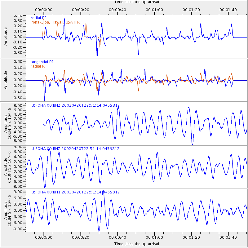
POHA Pohakuloa, Hawaii, USA - Earthquake Result Viewer
*The percent match for this event was below the threshold and hence no stack was calculated.
| Earthquake location: |
Mindanao, Philippines |
| Earthquake latitude/longitude: |
5.3/124.4 |
| Earthquake time(UTC): |
2002/04/20 (110) 22:39:45 GMT |
| Earthquake Depth: |
33 km |
| Earthquake Magnitude: |
5.7 MW |
| Earthquake Catalog/Contributor: |
NEIC PDE/NEIC PDE-M |
|
| Network: |
IU Global Seismograph Network (GSN - IRIS/USGS) |
| Station: |
POHA Pohakuloa, Hawaii, USA |
| Lat/Lon: |
19.76 N/155.53 W |
| Elevation: |
1967 m |
|
| Distance: |
78.9 deg |
| Az: |
70.986 deg |
| Baz: |
271.686 deg |
| Ray Param: |
$rayparam |
*The percent match for this event was below the threshold and hence was not used in the summary stack. |
|
| Radial Match: |
60.600315 % |
| Radial Bump: |
326 |
| Transverse Match: |
69.36844 % |
| Transverse Bump: |
375 |
| SOD ConfigId: |
590571 |
| Insert Time: |
2013-09-24 22:47:36.529 +0000 |
| GWidth: |
2.5 |
| Max Bumps: |
400 |
| Tol: |
0.001 |
|
Signal To Noise
| Channel | StoN | STA | LTA |
| IU:POHA:00:BHZ:20020420T22:51:14.045981Z | 2.7246478 | 5.2763053E-6 | 1.936509E-6 |
| IU:POHA:00:BH1:20020420T22:51:14.045981Z | 1.4152895 | 4.2889783E-6 | 3.03046E-6 |
| IU:POHA:00:BH2:20020420T22:51:14.045981Z | 0.54619384 | 1.1354695E-6 | 2.0788764E-6 |
| Arrivals |
| Ps | |
| PpPs | |
| PsPs/PpSs | |


