You are here: Home > Network List > IU - Global Seismograph Network (GSN - IRIS/USGS) Stations List
> Station RSSD Black Hills, South Dakota, USA > Earthquake Result Viewer
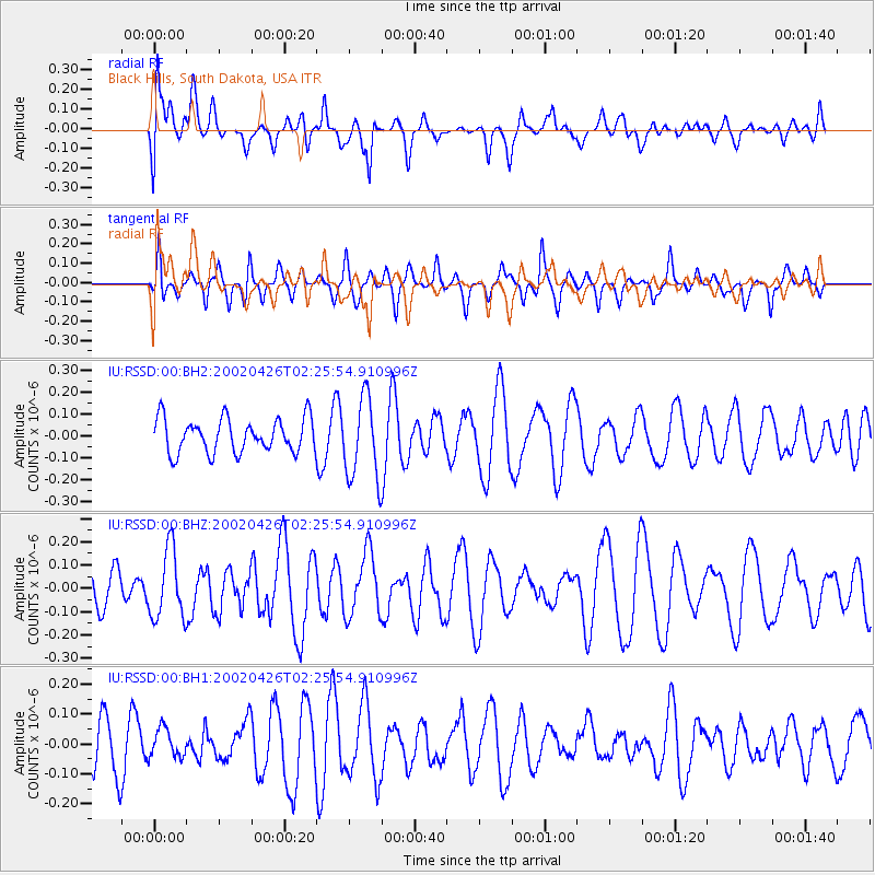
RSSD Black Hills, South Dakota, USA - Earthquake Result Viewer
*The percent match for this event was below the threshold and hence no stack was calculated.
| Earthquake location: |
Kermadec Islands Region |
| Earthquake latitude/longitude: |
-27.4/-176.7 |
| Earthquake time(UTC): |
2002/04/26 (116) 02:12:56 GMT |
| Earthquake Depth: |
33 km |
| Earthquake Magnitude: |
5.5 MW |
| Earthquake Catalog/Contributor: |
NEIC PDE/NEIC PDE-M |
|
| Network: |
IU Global Seismograph Network (GSN - IRIS/USGS) |
| Station: |
RSSD Black Hills, South Dakota, USA |
| Lat/Lon: |
44.12 N/104.04 W |
| Elevation: |
2060 m |
|
| Distance: |
97.3 deg |
| Az: |
43.879 deg |
| Baz: |
238.798 deg |
| Ray Param: |
$rayparam |
*The percent match for this event was below the threshold and hence was not used in the summary stack. |
|
| Radial Match: |
50.322796 % |
| Radial Bump: |
400 |
| Transverse Match: |
34.987804 % |
| Transverse Bump: |
324 |
| SOD ConfigId: |
590571 |
| Insert Time: |
2013-09-24 22:50:11.647 +0000 |
| GWidth: |
2.5 |
| Max Bumps: |
400 |
| Tol: |
0.001 |
|
Signal To Noise
| Channel | StoN | STA | LTA |
| IU:RSSD:00:BHZ:20020426T02:25:54.910996Z | 1.6385924 | 1.4962814E-7 | 9.1315044E-8 |
| IU:RSSD:00:BH1:20020426T02:25:54.910996Z | 0.56328017 | 4.902928E-8 | 8.704244E-8 |
| IU:RSSD:00:BH2:20020426T02:25:54.910996Z | 2.4076176 | 1.8647397E-7 | 7.745166E-8 |
| Arrivals |
| Ps | |
| PpPs | |
| PsPs/PpSs | |


