You are here: Home > Network List > IU - Global Seismograph Network (GSN - IRIS/USGS) Stations List
> Station JOHN Johnston Island, USA > Earthquake Result Viewer
JOHN Johnston Island, USA - Earthquake Result Viewer

| Earthquake location: |
Mariana Islands |
| Earthquake latitude/longitude: |
13.1/144.6 |
| Earthquake time(UTC): |
2002/04/26 (116) 16:06:07 GMT |
| Earthquake Depth: |
86 km |
| Earthquake Magnitude: |
7.1 MW, 6.5 MB, 7.1 MW |
| Earthquake Catalog/Contributor: |
NEIC PDE/NEIC PDE-M |
|
| Network: |
IU Global Seismograph Network (GSN - IRIS/USGS) |
| Station: |
JOHN Johnston Island, USA |
| Lat/Lon: |
16.73 N/169.53 W |
| Elevation: |
2.0 m |
|
| Distance: |
44.4 deg |
| Az: |
79.403 deg |
| Baz: |
271.754 deg |
| Ray Param: |
0.07167719 |
| Estimated Moho Depth: |
10.0 km |
| Estimated Crust Vp/Vs: |
1.99 |
| Assumed Crust Vp: |
4.24 km/s |
| Estimated Crust Vs: |
2.128 km/s |
| Estimated Crust Poisson's Ratio: |
0.33 |
|
| Radial Match: |
90.5093 % |
| Radial Bump: |
312 |
| Transverse Match: |
75.085846 % |
| Transverse Bump: |
400 |
| SOD ConfigId: |
590571 |
| Insert Time: |
2013-09-24 22:51:12.321 +0000 |
| GWidth: |
2.5 |
| Max Bumps: |
400 |
| Tol: |
0.001 |
|
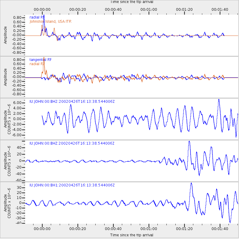
Signal To Noise
| Channel | StoN | STA | LTA |
| IU:JOHN:00:BHZ:20020426T16:13:38.544006Z | 0.57603407 | 9.419535E-7 | 1.6352391E-6 |
| IU:JOHN:00:BH1:20020426T16:13:38.544006Z | 1.748271 | 4.2403663E-6 | 2.425463E-6 |
| IU:JOHN:00:BH2:20020426T16:13:38.544006Z | 1.3885431 | 2.8101604E-6 | 2.0238194E-6 |
| Arrivals |
| Ps | 2.4 SECOND |
| PpPs | 6.9 SECOND |
| PsPs/PpSs | 9.3 SECOND |


