You are here: Home > Network List > IU - Global Seismograph Network (GSN - IRIS/USGS) Stations List
> Station SNZO South Karori, New Zealand > Earthquake Result Viewer
SNZO South Karori, New Zealand - Earthquake Result Viewer
| Earthquake location: |
Mariana Islands |
| Earthquake latitude/longitude: |
13.1/144.6 |
| Earthquake time(UTC): |
2002/04/26 (116) 16:06:07 GMT |
| Earthquake Depth: |
86 km |
| Earthquake Magnitude: |
7.1 MW, 6.5 MB, 7.1 MW |
| Earthquake Catalog/Contributor: |
NEIC PDE/NEIC PDE-M |
|
| Network: |
IU Global Seismograph Network (GSN - IRIS/USGS) |
| Station: |
SNZO South Karori, New Zealand |
| Lat/Lon: |
41.31 S/174.70 E |
| Elevation: |
62 m |
|
| Distance: |
60.8 deg |
| Az: |
154.378 deg |
| Baz: |
325.993 deg |
| Ray Param: |
0.061027505 |
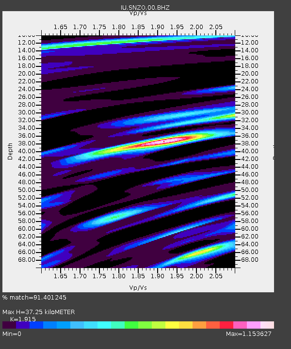
| Estimated Moho Depth: |
37.25 km |
| Estimated Crust Vp/Vs: |
1.91 |
| Assumed Crust Vp: |
6.461 km/s |
| Estimated Crust Vs: |
3.374 km/s |
| Estimated Crust Poisson's Ratio: |
0.31 |
|
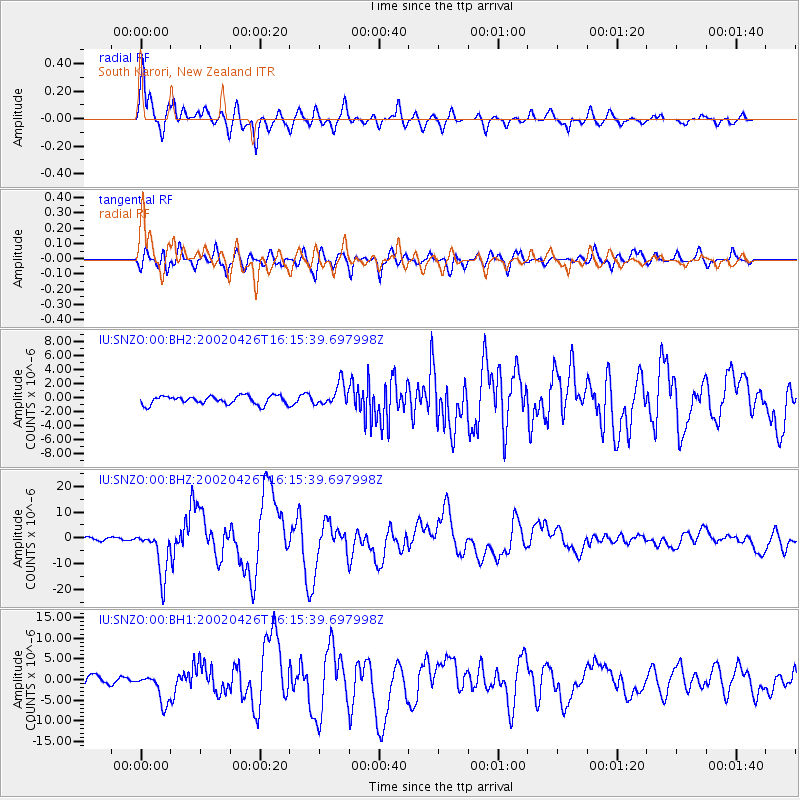
| Radial Match: |
91.401245 % |
| Radial Bump: |
400 |
| Transverse Match: |
82.88451 % |
| Transverse Bump: |
400 |
| SOD ConfigId: |
590571 |
| Insert Time: |
2013-09-24 22:51:21.500 +0000 |
| GWidth: |
2.5 |
| Max Bumps: |
400 |
| Tol: |
0.001 |
|
Signal To Noise
| Channel | StoN | STA | LTA |
| IU:SNZO:00:BHZ:20020426T16:15:39.697998Z | 12.698006 | 8.977284E-6 | 7.0698377E-7 |
| IU:SNZO:00:BH1:20020426T16:15:39.697998Z | 4.468029 | 3.5813644E-6 | 8.015535E-7 |
| IU:SNZO:00:BH2:20020426T16:15:39.697998Z | 2.64089 | 1.5754191E-6 | 5.9654855E-7 |
| Arrivals |
| Ps | 5.5 SECOND |
| PpPs | 16 SECOND |
| PsPs/PpSs | 22 SECOND |


