You are here: Home > Network List > IU - Global Seismograph Network (GSN - IRIS/USGS) Stations List
> Station JOHN Johnston Island, USA > Earthquake Result Viewer
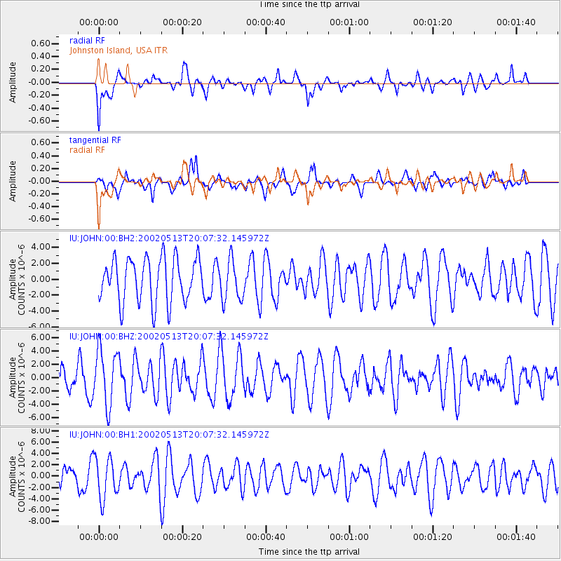
JOHN Johnston Island, USA - Earthquake Result Viewer
*The percent match for this event was below the threshold and hence no stack was calculated.
| Earthquake location: |
Philippine Islands Region |
| Earthquake latitude/longitude: |
19.1/121.2 |
| Earthquake time(UTC): |
2002/05/13 (133) 19:57:22 GMT |
| Earthquake Depth: |
33 km |
| Earthquake Magnitude: |
5.6 MB, 5.3 MS, 5.8 MW |
| Earthquake Catalog/Contributor: |
WHDF/NEIC |
|
| Network: |
IU Global Seismograph Network (GSN - IRIS/USGS) |
| Station: |
JOHN Johnston Island, USA |
| Lat/Lon: |
16.73 N/169.53 W |
| Elevation: |
2.0 m |
|
| Distance: |
65.5 deg |
| Az: |
79.884 deg |
| Baz: |
283.745 deg |
| Ray Param: |
$rayparam |
*The percent match for this event was below the threshold and hence was not used in the summary stack. |
|
| Radial Match: |
63.550182 % |
| Radial Bump: |
400 |
| Transverse Match: |
61.87434 % |
| Transverse Bump: |
400 |
| SOD ConfigId: |
590571 |
| Insert Time: |
2013-09-24 22:57:38.849 +0000 |
| GWidth: |
2.5 |
| Max Bumps: |
400 |
| Tol: |
0.001 |
|
Signal To Noise
| Channel | StoN | STA | LTA |
| IU:JOHN:00:BHZ:20020513T20:07:32.145972Z | 2.3278985 | 4.3236755E-6 | 1.85733E-6 |
| IU:JOHN:00:BH1:20020513T20:07:32.145972Z | 2.1150663 | 3.5500962E-6 | 1.6784799E-6 |
| IU:JOHN:00:BH2:20020513T20:07:32.145972Z | 0.92775774 | 2.5740317E-6 | 2.7744652E-6 |
| Arrivals |
| Ps | |
| PpPs | |
| PsPs/PpSs | |


