You are here: Home > Network List > IU - Global Seismograph Network (GSN - IRIS/USGS) Stations List
> Station POHA Pohakuloa, Hawaii, USA > Earthquake Result Viewer
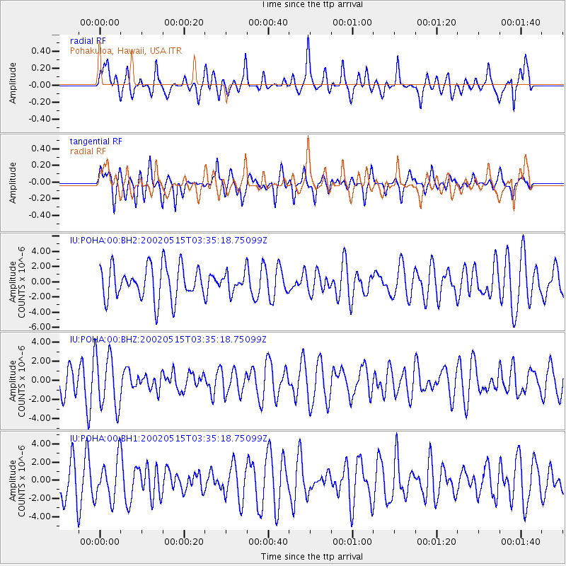
POHA Pohakuloa, Hawaii, USA - Earthquake Result Viewer
*The percent match for this event was below the threshold and hence no stack was calculated.
| Earthquake location: |
Tonga Islands |
| Earthquake latitude/longitude: |
-21.4/-174.3 |
| Earthquake time(UTC): |
2002/05/15 (135) 03:27:35 GMT |
| Earthquake Depth: |
10 km |
| Earthquake Magnitude: |
5.4 MB, 5.7 MS, 5.9 MW, 5.7 MW |
| Earthquake Catalog/Contributor: |
WHDF/NEIC |
|
| Network: |
IU Global Seismograph Network (GSN - IRIS/USGS) |
| Station: |
POHA Pohakuloa, Hawaii, USA |
| Lat/Lon: |
19.76 N/155.53 W |
| Elevation: |
1967 m |
|
| Distance: |
44.8 deg |
| Az: |
25.404 deg |
| Baz: |
205.115 deg |
| Ray Param: |
$rayparam |
*The percent match for this event was below the threshold and hence was not used in the summary stack. |
|
| Radial Match: |
44.87267 % |
| Radial Bump: |
400 |
| Transverse Match: |
40.34197 % |
| Transverse Bump: |
376 |
| SOD ConfigId: |
590571 |
| Insert Time: |
2013-09-24 22:58:52.473 +0000 |
| GWidth: |
2.5 |
| Max Bumps: |
400 |
| Tol: |
0.001 |
|
Signal To Noise
| Channel | StoN | STA | LTA |
| IU:POHA:00:BHZ:20020515T03:35:18.75099Z | 2.2020953 | 2.7610572E-6 | 1.2538319E-6 |
| IU:POHA:00:BH1:20020515T03:35:18.75099Z | 1.0745465 | 2.199321E-6 | 2.0467435E-6 |
| IU:POHA:00:BH2:20020515T03:35:18.75099Z | 0.57789296 | 1.271541E-6 | 2.2003055E-6 |
| Arrivals |
| Ps | |
| PpPs | |
| PsPs/PpSs | |


