You are here: Home > Network List > IU - Global Seismograph Network (GSN - IRIS/USGS) Stations List
> Station RSSD Black Hills, South Dakota, USA > Earthquake Result Viewer
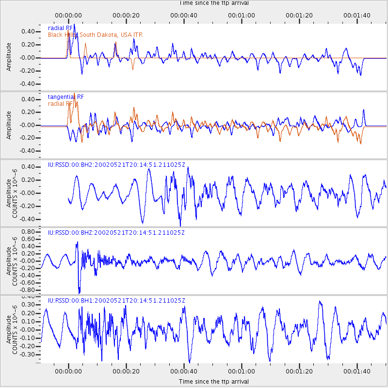
RSSD Black Hills, South Dakota, USA - Earthquake Result Viewer
*The percent match for this event was below the threshold and hence no stack was calculated.
| Earthquake location: |
Kuril Islands |
| Earthquake latitude/longitude: |
44.4/146.6 |
| Earthquake time(UTC): |
2002/05/21 (141) 20:04:16 GMT |
| Earthquake Depth: |
150 km |
| Earthquake Magnitude: |
5.5 MB, 5.5 MW, 5.5 MW |
| Earthquake Catalog/Contributor: |
WHDF/NEIC |
|
| Network: |
IU Global Seismograph Network (GSN - IRIS/USGS) |
| Station: |
RSSD Black Hills, South Dakota, USA |
| Lat/Lon: |
44.12 N/104.04 W |
| Elevation: |
2060 m |
|
| Distance: |
71.8 deg |
| Az: |
45.686 deg |
| Baz: |
314.62 deg |
| Ray Param: |
$rayparam |
*The percent match for this event was below the threshold and hence was not used in the summary stack. |
|
| Radial Match: |
76.78444 % |
| Radial Bump: |
400 |
| Transverse Match: |
40.569244 % |
| Transverse Bump: |
400 |
| SOD ConfigId: |
590571 |
| Insert Time: |
2013-09-24 23:01:33.924 +0000 |
| GWidth: |
2.5 |
| Max Bumps: |
400 |
| Tol: |
0.001 |
|
Signal To Noise
| Channel | StoN | STA | LTA |
| IU:RSSD:00:BHZ:20020521T20:14:51.211025Z | 3.9867709 | 3.3800399E-7 | 8.478139E-8 |
| IU:RSSD:00:BH1:20020521T20:14:51.211025Z | 0.8244184 | 1.2638547E-7 | 1.533026E-7 |
| IU:RSSD:00:BH2:20020521T20:14:51.211025Z | 1.1816895 | 1.420487E-7 | 1.2020816E-7 |
| Arrivals |
| Ps | |
| PpPs | |
| PsPs/PpSs | |


