You are here: Home > Network List > IU - Global Seismograph Network (GSN - IRIS/USGS) Stations List
> Station JOHN Johnston Island, USA > Earthquake Result Viewer
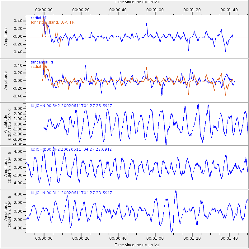
JOHN Johnston Island, USA - Earthquake Result Viewer
*The percent match for this event was below the threshold and hence no stack was calculated.
| Earthquake location: |
Southeast Of Loyalty Islands |
| Earthquake latitude/longitude: |
-21.6/169.9 |
| Earthquake time(UTC): |
2002/06/11 (162) 04:19:57 GMT |
| Earthquake Depth: |
33 km |
| Earthquake Magnitude: |
5.5 MW |
| Earthquake Catalog/Contributor: |
NEIC PDE/NEIC PDE-M |
|
| Network: |
IU Global Seismograph Network (GSN - IRIS/USGS) |
| Station: |
JOHN Johnston Island, USA |
| Lat/Lon: |
16.73 N/169.53 W |
| Elevation: |
2.0 m |
|
| Distance: |
43.1 deg |
| Az: |
29.562 deg |
| Baz: |
208.637 deg |
| Ray Param: |
$rayparam |
*The percent match for this event was below the threshold and hence was not used in the summary stack. |
|
| Radial Match: |
50.77784 % |
| Radial Bump: |
400 |
| Transverse Match: |
65.32459 % |
| Transverse Bump: |
400 |
| SOD ConfigId: |
590571 |
| Insert Time: |
2013-09-24 23:09:47.546 +0000 |
| GWidth: |
2.5 |
| Max Bumps: |
400 |
| Tol: |
0.001 |
|
Signal To Noise
| Channel | StoN | STA | LTA |
| IU:JOHN:00:BHZ:20020611T04:27:23.691Z | 2.1916366 | 2.8228126E-6 | 1.287993E-6 |
| IU:JOHN:00:BH1:20020611T04:27:23.691Z | 0.596384 | 1.093607E-6 | 1.8337296E-6 |
| IU:JOHN:00:BH2:20020611T04:27:23.691Z | 1.442767 | 1.99005E-6 | 1.3793286E-6 |
| Arrivals |
| Ps | |
| PpPs | |
| PsPs/PpSs | |


