You are here: Home > Network List > IU - Global Seismograph Network (GSN - IRIS/USGS) Stations List
> Station POHA Pohakuloa, Hawaii, USA > Earthquake Result Viewer
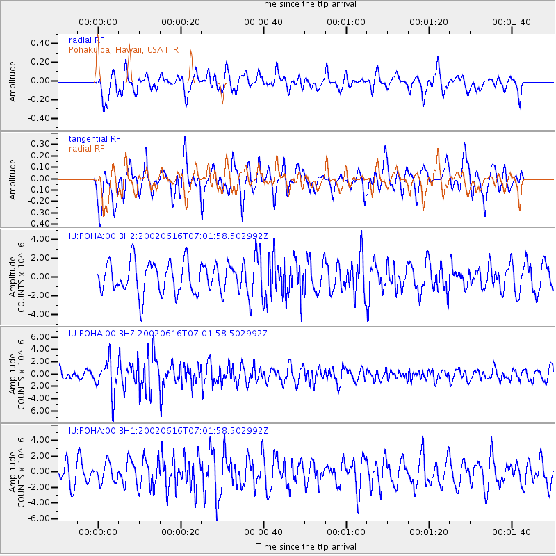
POHA Pohakuloa, Hawaii, USA - Earthquake Result Viewer
*The percent match for this event was below the threshold and hence no stack was calculated.
| Earthquake location: |
Fiji Islands Region |
| Earthquake latitude/longitude: |
-17.9/-178.7 |
| Earthquake time(UTC): |
2002/06/16 (167) 06:55:13 GMT |
| Earthquake Depth: |
569 km |
| Earthquake Magnitude: |
5.7 MB, 5.9 MW, 5.9 MW |
| Earthquake Catalog/Contributor: |
WHDF/NEIC |
|
| Network: |
IU Global Seismograph Network (GSN - IRIS/USGS) |
| Station: |
POHA Pohakuloa, Hawaii, USA |
| Lat/Lon: |
19.76 N/155.53 W |
| Elevation: |
1967 m |
|
| Distance: |
43.8 deg |
| Az: |
32.387 deg |
| Baz: |
212.794 deg |
| Ray Param: |
$rayparam |
*The percent match for this event was below the threshold and hence was not used in the summary stack. |
|
| Radial Match: |
66.432076 % |
| Radial Bump: |
400 |
| Transverse Match: |
65.40731 % |
| Transverse Bump: |
400 |
| SOD ConfigId: |
590571 |
| Insert Time: |
2013-09-24 23:12:56.231 +0000 |
| GWidth: |
2.5 |
| Max Bumps: |
400 |
| Tol: |
0.001 |
|
Signal To Noise
| Channel | StoN | STA | LTA |
| IU:POHA:00:BHZ:20020616T07:01:58.502992Z | 2.7637932 | 2.6886785E-6 | 9.728218E-7 |
| IU:POHA:00:BH1:20020616T07:01:58.502992Z | 0.9989682 | 1.2180709E-6 | 1.2193291E-6 |
| IU:POHA:00:BH2:20020616T07:01:58.502992Z | 0.7584878 | 1.3040383E-6 | 1.7192607E-6 |
| Arrivals |
| Ps | |
| PpPs | |
| PsPs/PpSs | |


