You are here: Home > Network List > AK - Alaska Regional Network Stations List
> Station WAX Waxell Ridge, AK, USA > Earthquake Result Viewer
WAX Waxell Ridge, AK, USA - Earthquake Result Viewer
| Earthquake location: |
Tonga Islands |
| Earthquake latitude/longitude: |
-15.2/-173.5 |
| Earthquake time(UTC): |
2013/08/01 (213) 20:01:43 GMT |
| Earthquake Depth: |
32 km |
| Earthquake Magnitude: |
6.0 MW, 5.8 MW, 5.9 MS, 6.1 MB |
| Earthquake Catalog/Contributor: |
NEIC PDE/NEIC PDE-W |
|
| Network: |
AK Alaska Regional Network |
| Station: |
WAX Waxell Ridge, AK, USA |
| Lat/Lon: |
60.45 N/142.85 W |
| Elevation: |
1003 m |
|
| Distance: |
79.4 deg |
| Az: |
14.9 deg |
| Baz: |
210.046 deg |
| Ray Param: |
0.048974995 |
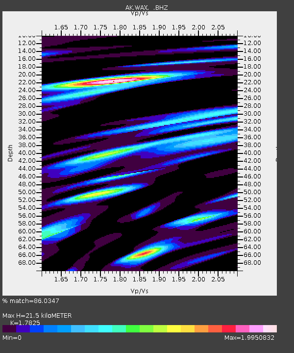
| Estimated Moho Depth: |
21.5 km |
| Estimated Crust Vp/Vs: |
1.78 |
| Assumed Crust Vp: |
6.566 km/s |
| Estimated Crust Vs: |
3.684 km/s |
| Estimated Crust Poisson's Ratio: |
0.27 |
|
| Radial Match: |
86.0347 % |
| Radial Bump: |
400 |
| Transverse Match: |
77.56447 % |
| Transverse Bump: |
400 |
| SOD ConfigId: |
589702 |
| Insert Time: |
2013-09-24 23:14:05.854 +0000 |
| GWidth: |
2.5 |
| Max Bumps: |
400 |
| Tol: |
0.001 |
|

Signal To Noise
| Channel | StoN | STA | LTA |
| AK:WAX: :BHZ:20130801T20:13:14.728003Z | 16.824991 | 1.6515129E-6 | 9.815832E-8 |
| AK:WAX: :BHN:20130801T20:13:14.728003Z | 3.1342504 | 5.975263E-7 | 1.9064407E-7 |
| AK:WAX: :BHE:20130801T20:13:14.728003Z | 2.0500882 | 5.6822785E-7 | 2.7717238E-7 |
| Arrivals |
| Ps | 2.6 SECOND |
| PpPs | 8.8 SECOND |
| PsPs/PpSs | 11 SECOND |


