You are here: Home > Network List > IU - Global Seismograph Network (GSN - IRIS/USGS) Stations List
> Station RSSD Black Hills, South Dakota, USA > Earthquake Result Viewer
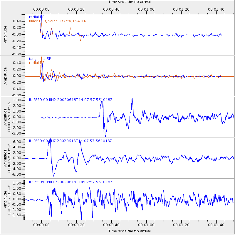
RSSD Black Hills, South Dakota, USA - Earthquake Result Viewer
*The percent match for this event was below the threshold and hence no stack was calculated.
| Earthquake location: |
Near Coast Of Central Chile |
| Earthquake latitude/longitude: |
-30.8/-71.1 |
| Earthquake time(UTC): |
2002/06/18 (169) 13:56:22 GMT |
| Earthquake Depth: |
54 km |
| Earthquake Magnitude: |
6.0 MB, 6.6 MW, 6.4 MW |
| Earthquake Catalog/Contributor: |
WHDF/NEIC |
|
| Network: |
IU Global Seismograph Network (GSN - IRIS/USGS) |
| Station: |
RSSD Black Hills, South Dakota, USA |
| Lat/Lon: |
44.12 N/104.04 W |
| Elevation: |
2060 m |
|
| Distance: |
80.4 deg |
| Az: |
336.617 deg |
| Baz: |
151.696 deg |
| Ray Param: |
$rayparam |
*The percent match for this event was below the threshold and hence was not used in the summary stack. |
|
| Radial Match: |
96.638336 % |
| Radial Bump: |
400 |
| Transverse Match: |
93.42287 % |
| Transverse Bump: |
400 |
| SOD ConfigId: |
590571 |
| Insert Time: |
2013-09-24 23:14:55.719 +0000 |
| GWidth: |
2.5 |
| Max Bumps: |
400 |
| Tol: |
0.001 |
|
Signal To Noise
| Channel | StoN | STA | LTA |
| IU:RSSD:00:BHZ:20020618T14:07:57.561018Z | 33.908264 | 2.8297657E-6 | 8.345357E-8 |
| IU:RSSD:00:BH1:20020618T14:07:57.561018Z | 8.10613 | 3.8693557E-7 | 4.7733703E-8 |
| IU:RSSD:00:BH2:20020618T14:07:57.561018Z | 17.263828 | 1.1521521E-6 | 6.673793E-8 |
| Arrivals |
| Ps | |
| PpPs | |
| PsPs/PpSs | |


