You are here: Home > Network List > TA - USArray Transportable Network (new EarthScope stations) Stations List
> Station N60A Cedar Hill Farm, Mount Bethel, PA, USA > Earthquake Result Viewer
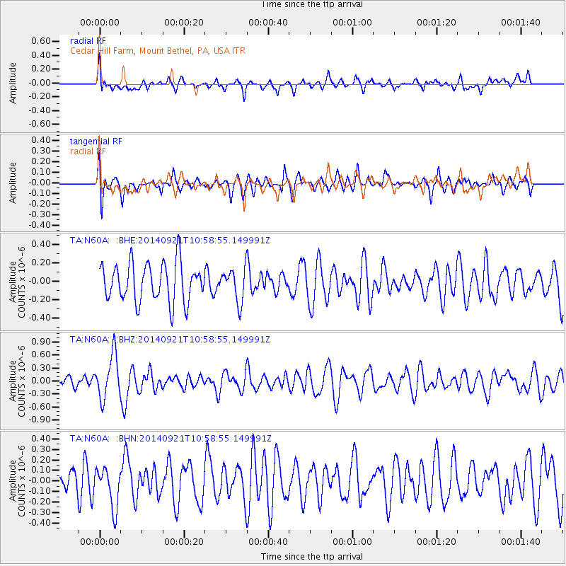
N60A Cedar Hill Farm, Mount Bethel, PA, USA - Earthquake Result Viewer
*The percent match for this event was below the threshold and hence no stack was calculated.
| Earthquake location: |
Iceland |
| Earthquake latitude/longitude: |
64.5/-17.4 |
| Earthquake time(UTC): |
2014/09/21 (264) 10:51:47 GMT |
| Earthquake Depth: |
2.6 km |
| Earthquake Magnitude: |
5.5 MW |
| Earthquake Catalog/Contributor: |
ISC/ISC |
|
| Network: |
TA USArray Transportable Network (new EarthScope stations) |
| Station: |
N60A Cedar Hill Farm, Mount Bethel, PA, USA |
| Lat/Lon: |
40.87 N/75.10 W |
| Elevation: |
189 m |
|
| Distance: |
40.3 deg |
| Az: |
262.605 deg |
| Baz: |
34.438 deg |
| Ray Param: |
$rayparam |
*The percent match for this event was below the threshold and hence was not used in the summary stack. |
|
| Radial Match: |
57.374683 % |
| Radial Bump: |
400 |
| Transverse Match: |
47.26425 % |
| Transverse Bump: |
400 |
| SOD ConfigId: |
3390531 |
| Insert Time: |
2019-04-14 03:31:55.987 +0000 |
| GWidth: |
2.5 |
| Max Bumps: |
400 |
| Tol: |
0.001 |
|
Signal To Noise
| Channel | StoN | STA | LTA |
| TA:N60A: :BHZ:20140921T10:58:55.149991Z | 3.244118 | 5.1810974E-7 | 1.5970743E-7 |
| TA:N60A: :BHN:20140921T10:58:55.149991Z | 1.1118401 | 1.9633585E-7 | 1.765864E-7 |
| TA:N60A: :BHE:20140921T10:58:55.149991Z | 0.8861603 | 1.859854E-7 | 2.0987783E-7 |
| Arrivals |
| Ps | |
| PpPs | |
| PsPs/PpSs | |


