You are here: Home > Network List > II - Global Seismograph Network (GSN - IRIS/IDA) Stations List
> Station COCO West Island, Cocos (Keeling) Islands > Earthquake Result Viewer
COCO West Island, Cocos (Keeling) Islands - Earthquake Result Viewer
| Earthquake location: |
E. Russia-N.E. China Border Reg. |
| Earthquake latitude/longitude: |
43.8/130.7 |
| Earthquake time(UTC): |
2002/06/28 (179) 17:19:30 GMT |
| Earthquake Depth: |
566 km |
| Earthquake Magnitude: |
6.7 MB, 7.3 MW, 7.3 MW |
| Earthquake Catalog/Contributor: |
WHDF/NEIC |
|
| Network: |
II Global Seismograph Network (GSN - IRIS/IDA) |
| Station: |
COCO West Island, Cocos (Keeling) Islands |
| Lat/Lon: |
12.19 S/96.83 E |
| Elevation: |
1.0 m |
|
| Distance: |
63.6 deg |
| Az: |
217.41 deg |
| Baz: |
26.76 deg |
| Ray Param: |
0.05731902 |
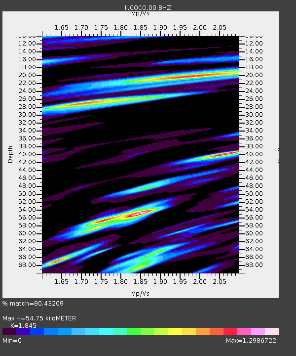
| Estimated Moho Depth: |
54.75 km |
| Estimated Crust Vp/Vs: |
1.85 |
| Assumed Crust Vp: |
4.24 km/s |
| Estimated Crust Vs: |
2.298 km/s |
| Estimated Crust Poisson's Ratio: |
0.29 |
|
| Radial Match: |
80.43209 % |
| Radial Bump: |
400 |
| Transverse Match: |
71.652 % |
| Transverse Bump: |
400 |
| SOD ConfigId: |
590571 |
| Insert Time: |
2013-09-24 23:20:09.186 +0000 |
| GWidth: |
2.5 |
| Max Bumps: |
400 |
| Tol: |
0.001 |
|
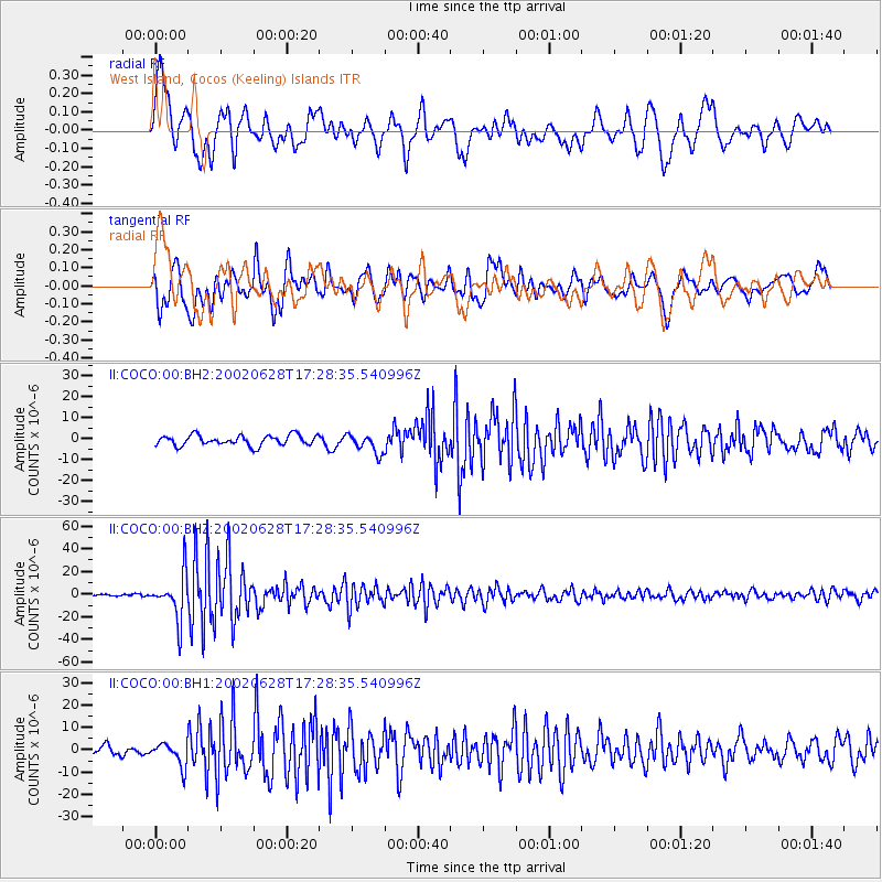
Signal To Noise
| Channel | StoN | STA | LTA |
| II:COCO:00:BHZ:20020628T17:28:35.540996Z | 17.253885 | 1.9830739E-5 | 1.1493493E-6 |
| II:COCO:00:BH1:20020628T17:28:35.540996Z | 3.154308 | 5.168075E-6 | 1.638418E-6 |
| II:COCO:00:BH2:20020628T17:28:35.540996Z | 1.8983436 | 4.6388977E-6 | 2.4436554E-6 |
| Arrivals |
| Ps | 11 SECOND |
| PpPs | 36 SECOND |
| PsPs/PpSs | 47 SECOND |


