You are here: Home > Network List > IU - Global Seismograph Network (GSN - IRIS/USGS) Stations List
> Station RSSD Black Hills, South Dakota, USA > Earthquake Result Viewer
RSSD Black Hills, South Dakota, USA - Earthquake Result Viewer
| Earthquake location: |
E. Russia-N.E. China Border Reg. |
| Earthquake latitude/longitude: |
43.8/130.7 |
| Earthquake time(UTC): |
2002/06/28 (179) 17:19:30 GMT |
| Earthquake Depth: |
566 km |
| Earthquake Magnitude: |
6.7 MB, 7.3 MW, 7.3 MW |
| Earthquake Catalog/Contributor: |
WHDF/NEIC |
|
| Network: |
IU Global Seismograph Network (GSN - IRIS/USGS) |
| Station: |
RSSD Black Hills, South Dakota, USA |
| Lat/Lon: |
44.12 N/104.04 W |
| Elevation: |
2060 m |
|
| Distance: |
79.8 deg |
| Az: |
36.668 deg |
| Baz: |
323.068 deg |
| Ray Param: |
0.04696283 |
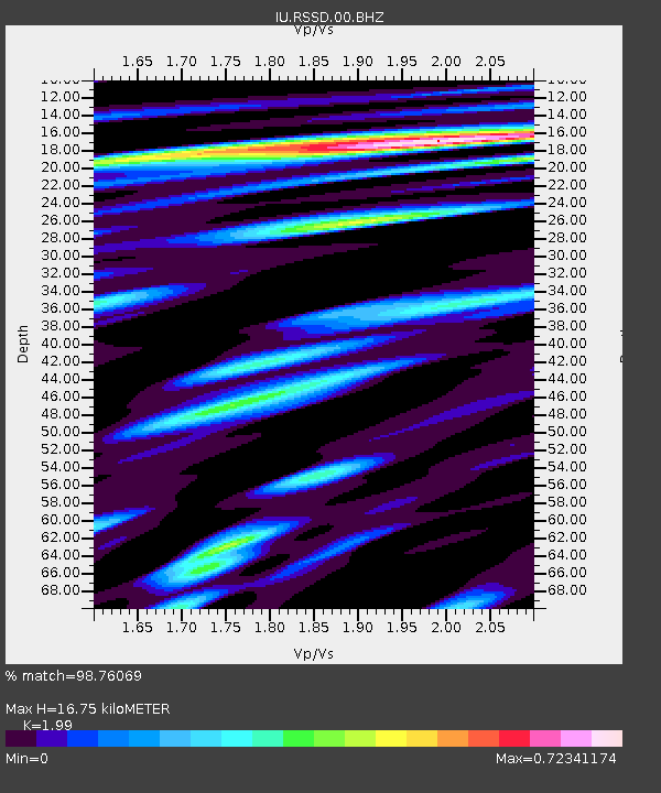
| Estimated Moho Depth: |
16.75 km |
| Estimated Crust Vp/Vs: |
1.99 |
| Assumed Crust Vp: |
6.242 km/s |
| Estimated Crust Vs: |
3.137 km/s |
| Estimated Crust Poisson's Ratio: |
0.33 |
|
| Radial Match: |
98.76069 % |
| Radial Bump: |
355 |
| Transverse Match: |
95.857056 % |
| Transverse Bump: |
400 |
| SOD ConfigId: |
590571 |
| Insert Time: |
2013-09-24 23:20:26.155 +0000 |
| GWidth: |
2.5 |
| Max Bumps: |
400 |
| Tol: |
0.001 |
|
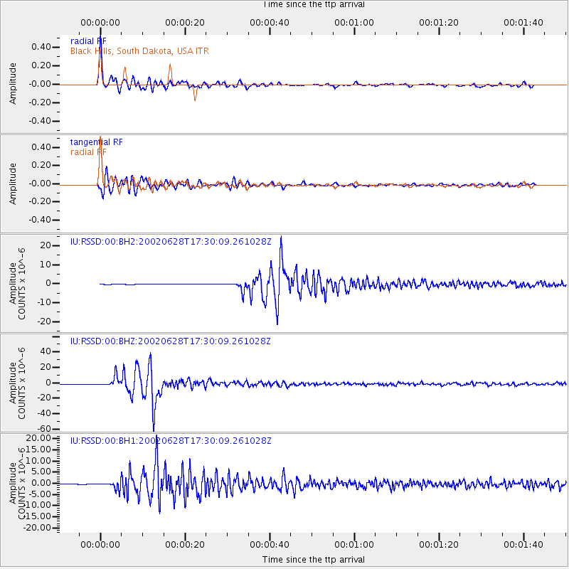
Signal To Noise
| Channel | StoN | STA | LTA |
| IU:RSSD:00:BHZ:20020628T17:30:09.261028Z | 51.441525 | 6.6758416E-6 | 1.2977534E-7 |
| IU:RSSD:00:BH1:20020628T17:30:09.261028Z | 21.675108 | 1.5487682E-6 | 7.145377E-8 |
| IU:RSSD:00:BH2:20020628T17:30:09.261028Z | 31.949072 | 2.4644492E-6 | 7.7136804E-8 |
| Arrivals |
| Ps | 2.7 SECOND |
| PpPs | 7.8 SECOND |
| PsPs/PpSs | 11 SECOND |


