You are here: Home > Network List > IU - Global Seismograph Network (GSN - IRIS/USGS) Stations List
> Station POHA Pohakuloa, Hawaii, USA > Earthquake Result Viewer
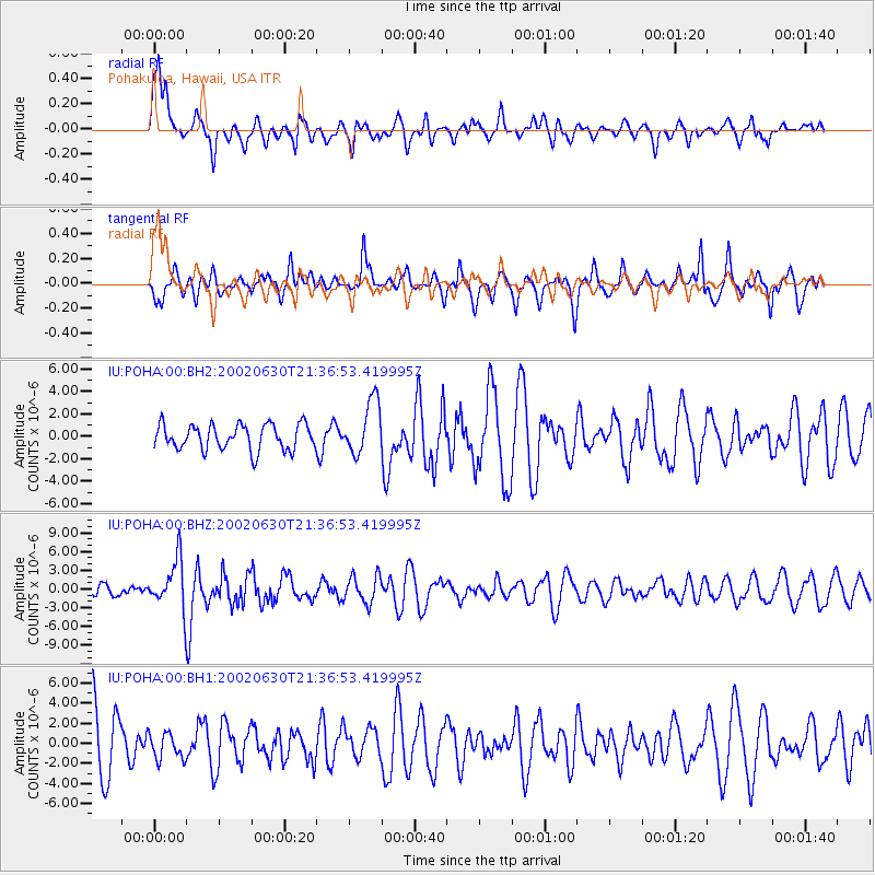
POHA Pohakuloa, Hawaii, USA - Earthquake Result Viewer
*The percent match for this event was below the threshold and hence no stack was calculated.
| Earthquake location: |
South Of Fiji Islands |
| Earthquake latitude/longitude: |
-22.2/179.2 |
| Earthquake time(UTC): |
2002/06/30 (181) 21:29:36 GMT |
| Earthquake Depth: |
620 km |
| Earthquake Magnitude: |
5.5 MB, 6.5 MW, 6.4 MW |
| Earthquake Catalog/Contributor: |
WHDF/NEIC |
|
| Network: |
IU Global Seismograph Network (GSN - IRIS/USGS) |
| Station: |
POHA Pohakuloa, Hawaii, USA |
| Lat/Lon: |
19.76 N/155.53 W |
| Elevation: |
1967 m |
|
| Distance: |
48.4 deg |
| Az: |
32.432 deg |
| Baz: |
211.85 deg |
| Ray Param: |
$rayparam |
*The percent match for this event was below the threshold and hence was not used in the summary stack. |
|
| Radial Match: |
60.680046 % |
| Radial Bump: |
387 |
| Transverse Match: |
62.672256 % |
| Transverse Bump: |
394 |
| SOD ConfigId: |
590571 |
| Insert Time: |
2013-09-24 23:21:37.985 +0000 |
| GWidth: |
2.5 |
| Max Bumps: |
400 |
| Tol: |
0.001 |
|
Signal To Noise
| Channel | StoN | STA | LTA |
| IU:POHA:00:BHZ:20020630T21:36:53.419995Z | 3.43943 | 3.8851126E-6 | 1.1295804E-6 |
| IU:POHA:00:BH1:20020630T21:36:53.419995Z | 0.37520868 | 1.2896435E-6 | 3.4371367E-6 |
| IU:POHA:00:BH2:20020630T21:36:53.419995Z | 2.1388237 | 2.4092947E-6 | 1.1264578E-6 |
| Arrivals |
| Ps | |
| PpPs | |
| PsPs/PpSs | |


