You are here: Home > Network List > IU - Global Seismograph Network (GSN - IRIS/USGS) Stations List
> Station JOHN Johnston Island, USA > Earthquake Result Viewer
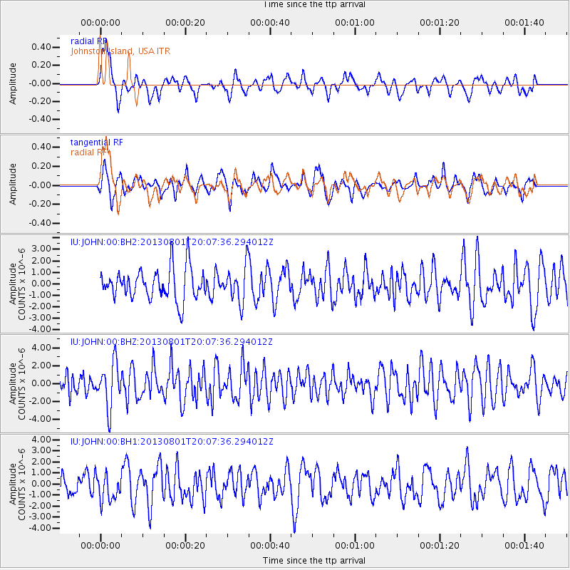
JOHN Johnston Island, USA - Earthquake Result Viewer
*The percent match for this event was below the threshold and hence no stack was calculated.
| Earthquake location: |
Tonga Islands |
| Earthquake latitude/longitude: |
-15.2/-173.5 |
| Earthquake time(UTC): |
2013/08/01 (213) 20:01:43 GMT |
| Earthquake Depth: |
32 km |
| Earthquake Magnitude: |
6.0 MW, 5.8 MW, 5.9 MS, 6.1 MB |
| Earthquake Catalog/Contributor: |
NEIC PDE/NEIC PDE-W |
|
| Network: |
IU Global Seismograph Network (GSN - IRIS/USGS) |
| Station: |
JOHN Johnston Island, USA |
| Lat/Lon: |
16.73 N/169.53 W |
| Elevation: |
2.0 m |
|
| Distance: |
32.0 deg |
| Az: |
7.192 deg |
| Baz: |
187.245 deg |
| Ray Param: |
$rayparam |
*The percent match for this event was below the threshold and hence was not used in the summary stack. |
|
| Radial Match: |
58.619316 % |
| Radial Bump: |
400 |
| Transverse Match: |
53.743217 % |
| Transverse Bump: |
395 |
| SOD ConfigId: |
589702 |
| Insert Time: |
2013-09-24 23:22:55.372 +0000 |
| GWidth: |
2.5 |
| Max Bumps: |
400 |
| Tol: |
0.001 |
|
Signal To Noise
| Channel | StoN | STA | LTA |
| IU:JOHN:00:BHZ:20130801T20:07:36.294012Z | 2.4240735 | 2.5595814E-6 | 1.055901E-6 |
| IU:JOHN:00:BH1:20130801T20:07:36.294012Z | 1.0104296 | 1.1769531E-6 | 1.1648048E-6 |
| IU:JOHN:00:BH2:20130801T20:07:36.294012Z | 1.190742 | 1.611035E-6 | 1.3529673E-6 |
| Arrivals |
| Ps | |
| PpPs | |
| PsPs/PpSs | |


