You are here: Home > Network List > IU - Global Seismograph Network (GSN - IRIS/USGS) Stations List
> Station RSSD Black Hills, South Dakota, USA > Earthquake Result Viewer
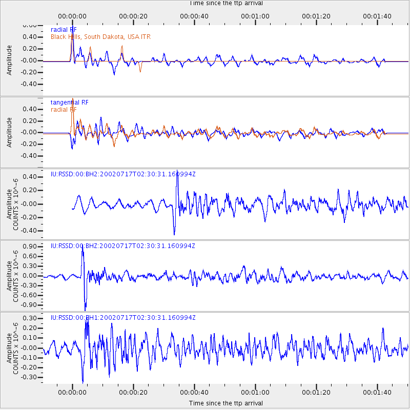
RSSD Black Hills, South Dakota, USA - Earthquake Result Viewer
*The percent match for this event was below the threshold and hence no stack was calculated.
| Earthquake location: |
Kuril Islands |
| Earthquake latitude/longitude: |
48.5/153.3 |
| Earthquake time(UTC): |
2002/07/17 (198) 02:20:33 GMT |
| Earthquake Depth: |
148 km |
| Earthquake Magnitude: |
5.3 MB, 5.6 MW, 5.6 MW |
| Earthquake Catalog/Contributor: |
WHDF/NEIC |
|
| Network: |
IU Global Seismograph Network (GSN - IRIS/USGS) |
| Station: |
RSSD Black Hills, South Dakota, USA |
| Lat/Lon: |
44.12 N/104.04 W |
| Elevation: |
2060 m |
|
| Distance: |
65.6 deg |
| Az: |
50.481 deg |
| Baz: |
314.589 deg |
| Ray Param: |
$rayparam |
*The percent match for this event was below the threshold and hence was not used in the summary stack. |
|
| Radial Match: |
73.1837 % |
| Radial Bump: |
371 |
| Transverse Match: |
63.36009 % |
| Transverse Bump: |
400 |
| SOD ConfigId: |
590571 |
| Insert Time: |
2013-09-24 23:26:14.490 +0000 |
| GWidth: |
2.5 |
| Max Bumps: |
400 |
| Tol: |
0.001 |
|
Signal To Noise
| Channel | StoN | STA | LTA |
| IU:RSSD:00:BHZ:20020717T02:30:31.160994Z | 11.129895 | 4.1948365E-7 | 3.768981E-8 |
| IU:RSSD:00:BH1:20020717T02:30:31.160994Z | 3.1360846 | 1.3462129E-7 | 4.292655E-8 |
| IU:RSSD:00:BH2:20020717T02:30:31.160994Z | 3.8472748 | 1.9998518E-7 | 5.1980994E-8 |
| Arrivals |
| Ps | |
| PpPs | |
| PsPs/PpSs | |


