You are here: Home > Network List > PB - Plate Boundary Observatory Borehole Seismic Network Stations List
> Station B082 pathfi082bcs2006, Anza, CA, USA > Earthquake Result Viewer
B082 pathfi082bcs2006, Anza, CA, USA - Earthquake Result Viewer
| Earthquake location: |
Tonga Islands |
| Earthquake latitude/longitude: |
-15.2/-173.5 |
| Earthquake time(UTC): |
2013/08/01 (213) 20:01:43 GMT |
| Earthquake Depth: |
32 km |
| Earthquake Magnitude: |
6.0 MW, 5.8 MW, 5.9 MS, 6.1 MB |
| Earthquake Catalog/Contributor: |
NEIC PDE/NEIC PDE-W |
|
| Network: |
PB Plate Boundary Observatory Borehole Seismic Network |
| Station: |
B082 pathfi082bcs2006, Anza, CA, USA |
| Lat/Lon: |
33.60 N/116.60 W |
| Elevation: |
1375 m |
|
| Distance: |
72.8 deg |
| Az: |
47.058 deg |
| Baz: |
237.844 deg |
| Ray Param: |
0.05338916 |
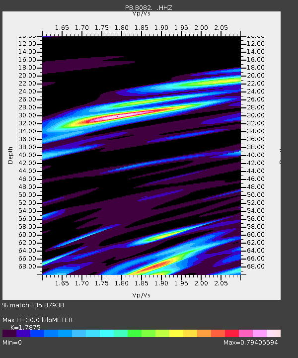
| Estimated Moho Depth: |
30.0 km |
| Estimated Crust Vp/Vs: |
1.79 |
| Assumed Crust Vp: |
6.264 km/s |
| Estimated Crust Vs: |
3.504 km/s |
| Estimated Crust Poisson's Ratio: |
0.27 |
|
| Radial Match: |
85.87938 % |
| Radial Bump: |
400 |
| Transverse Match: |
77.74255 % |
| Transverse Bump: |
400 |
| SOD ConfigId: |
589702 |
| Insert Time: |
2013-09-24 23:26:19.258 +0000 |
| GWidth: |
2.5 |
| Max Bumps: |
400 |
| Tol: |
0.001 |
|

Signal To Noise
| Channel | StoN | STA | LTA |
| PB:B082: :HHZ:20130801T20:12:37.428992Z | 12.396774 | 2.9608502E-8 | 2.3884037E-9 |
| PB:B082: :HH1:20130801T20:12:37.428992Z | 2.4661884 | 5.8482104E-9 | 2.3713558E-9 |
| PB:B082: :HH2:20130801T20:12:37.428992Z | 2.0816195 | 5.0818163E-9 | 2.44128E-9 |
| Arrivals |
| Ps | 3.9 SECOND |
| PpPs | 13 SECOND |
| PsPs/PpSs | 17 SECOND |


