You are here: Home > Network List > IU - Global Seismograph Network (GSN - IRIS/USGS) Stations List
> Station RSSD Black Hills, South Dakota, USA > Earthquake Result Viewer
RSSD Black Hills, South Dakota, USA - Earthquake Result Viewer
*The percent match for this event was below the threshold and hence no stack was calculated.
| Earthquake location: |
Kuril Islands |
| Earthquake latitude/longitude: |
43.7/147.5 |
| Earthquake time(UTC): |
2002/07/25 (206) 12:31:01 GMT |
| Earthquake Depth: |
33 km |
| Earthquake Magnitude: |
5.7 MW, 5.6 MB, 5.7 MW |
| Earthquake Catalog/Contributor: |
NEIC PDE/NEIC PDE-M |
|
| Network: |
IU Global Seismograph Network (GSN - IRIS/USGS) |
| Station: |
RSSD Black Hills, South Dakota, USA |
| Lat/Lon: |
44.12 N/104.04 W |
| Elevation: |
2060 m |
|
| Distance: |
71.8 deg |
| Az: |
45.994 deg |
| Baz: |
313.548 deg |
| Ray Param: |
$rayparam |
*The percent match for this event was below the threshold and hence was not used in the summary stack. |
|
| Radial Match: |
66.385544 % |
| Radial Bump: |
400 |
| Transverse Match: |
55.26744 % |
| Transverse Bump: |
400 |
| SOD ConfigId: |
590571 |
| Insert Time: |
2013-09-24 23:28:11.519 +0000 |
| GWidth: |
2.5 |
| Max Bumps: |
400 |
| Tol: |
0.001 |
|
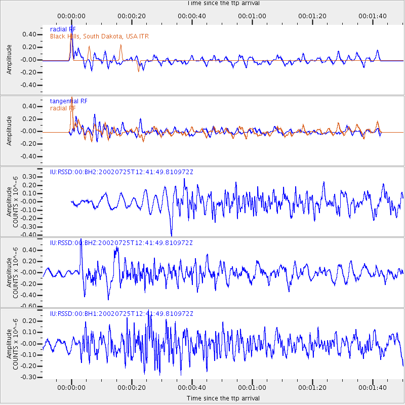
Signal To Noise
| Channel | StoN | STA | LTA |
| IU:RSSD:00:BHZ:20020725T12:41:49.810972Z | 2.6625853 | 2.0903072E-7 | 7.850667E-8 |
| IU:RSSD:00:BH1:20020725T12:41:49.810972Z | 1.9438227 | 7.5393494E-8 | 3.8786197E-8 |
| IU:RSSD:00:BH2:20020725T12:41:49.810972Z | 2.9386005 | 1.6679272E-7 | 5.6759237E-8 |
| Arrivals |
| Ps | |
| PpPs | |
| PsPs/PpSs | |


