You are here: Home > Network List > CN - Canadian National Seismograph Network Stations List
> Station SCHQ Schefferville, PQ > Earthquake Result Viewer
SCHQ Schefferville, PQ - Earthquake Result Viewer
| Earthquake location: |
Hindu Kush Region, Afghanistan |
| Earthquake latitude/longitude: |
36.5/70.5 |
| Earthquake time(UTC): |
2002/03/03 (062) 12:08:19 GMT |
| Earthquake Depth: |
226 km |
| Earthquake Magnitude: |
6.6 MB, 7.4 MW, 7.3 MW |
| Earthquake Catalog/Contributor: |
WHDF/NEIC |
|
| Network: |
CN Canadian National Seismograph Network |
| Station: |
SCHQ Schefferville, PQ |
| Lat/Lon: |
54.83 N/66.83 W |
| Elevation: |
501 m |
|
| Distance: |
81.9 deg |
| Az: |
336.661 deg |
| Baz: |
33.485 deg |
| Ray Param: |
0.04668173 |
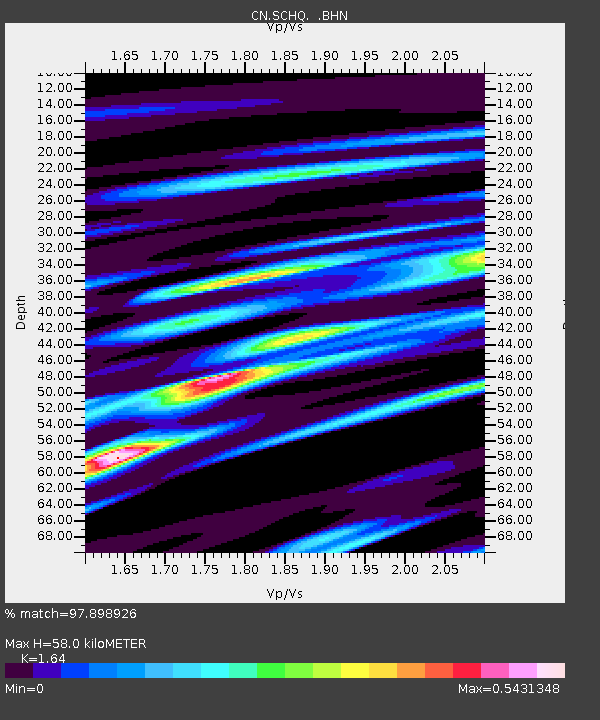
| Estimated Moho Depth: |
58.0 km |
| Estimated Crust Vp/Vs: |
1.64 |
| Assumed Crust Vp: |
6.61 km/s |
| Estimated Crust Vs: |
4.03 km/s |
| Estimated Crust Poisson's Ratio: |
0.20 |
|
| Radial Match: |
97.898926 % |
| Radial Bump: |
367 |
| Transverse Match: |
89.99985 % |
| Transverse Bump: |
400 |
| SOD ConfigId: |
20082 |
| Insert Time: |
2010-02-27 07:23:48.239 +0000 |
| GWidth: |
2.5 |
| Max Bumps: |
400 |
| Tol: |
0.001 |
|

Signal To Noise
| Channel | StoN | STA | LTA |
| CN:SCHQ: :BHN:20020303T12:19:42.849009Z | 10.475831 | 4.0425325E-6 | 3.8589135E-7 |
| CN:SCHQ: :BHE:20020303T12:19:42.849009Z | 8.918433 | 2.7292447E-6 | 3.0602288E-7 |
| CN:SCHQ: :BHZ:20020303T12:19:42.849009Z | 12.144162 | 1.3990922E-5 | 1.1520698E-6 |
| Arrivals |
| Ps | 5.8 SECOND |
| PpPs | 22 SECOND |
| PsPs/PpSs | 28 SECOND |


