You are here: Home > Network List > TA - USArray Transportable Network (new EarthScope stations) Stations List
> Station J01E Myrtle Point, OR, USA > Earthquake Result Viewer
J01E Myrtle Point, OR, USA - Earthquake Result Viewer
| Earthquake location: |
Tonga Islands |
| Earthquake latitude/longitude: |
-15.2/-173.5 |
| Earthquake time(UTC): |
2013/08/01 (213) 20:01:43 GMT |
| Earthquake Depth: |
32 km |
| Earthquake Magnitude: |
6.0 MW, 5.8 MW, 5.9 MS, 6.1 MB |
| Earthquake Catalog/Contributor: |
NEIC PDE/NEIC PDE-W |
|
| Network: |
TA USArray Transportable Network (new EarthScope stations) |
| Station: |
J01E Myrtle Point, OR, USA |
| Lat/Lon: |
43.16 N/123.93 W |
| Elevation: |
128 m |
|
| Distance: |
73.7 deg |
| Az: |
35.463 deg |
| Baz: |
229.939 deg |
| Ray Param: |
0.05275564 |
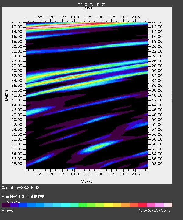
| Estimated Moho Depth: |
11.5 km |
| Estimated Crust Vp/Vs: |
1.71 |
| Assumed Crust Vp: |
6.522 km/s |
| Estimated Crust Vs: |
3.814 km/s |
| Estimated Crust Poisson's Ratio: |
0.24 |
|
| Radial Match: |
88.366684 % |
| Radial Bump: |
400 |
| Transverse Match: |
82.85285 % |
| Transverse Bump: |
400 |
| SOD ConfigId: |
589702 |
| Insert Time: |
2013-09-24 23:29:59.617 +0000 |
| GWidth: |
2.5 |
| Max Bumps: |
400 |
| Tol: |
0.001 |
|
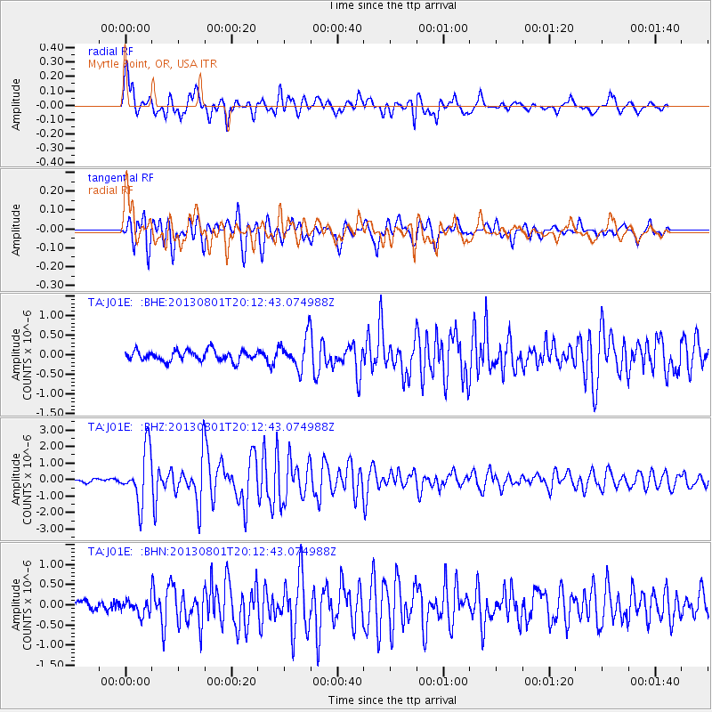
Signal To Noise
| Channel | StoN | STA | LTA |
| TA:J01E: :BHZ:20130801T20:12:43.074988Z | 11.123027 | 1.6243554E-6 | 1.4603536E-7 |
| TA:J01E: :BHN:20130801T20:12:43.074988Z | 1.5944697 | 1.7454047E-7 | 1.0946616E-7 |
| TA:J01E: :BHE:20130801T20:12:43.074988Z | 3.0707939 | 4.0169041E-7 | 1.3080997E-7 |
| Arrivals |
| Ps | 1.3 SECOND |
| PpPs | 4.6 SECOND |
| PsPs/PpSs | 5.9 SECOND |


