You are here: Home > Network List > TA - USArray Transportable Network (new EarthScope stations) Stations List
> Station L04D Klamath Falls, OR, USA > Earthquake Result Viewer
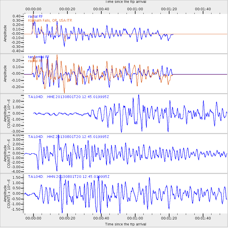
L04D Klamath Falls, OR, USA - Earthquake Result Viewer
*The percent match for this event was below the threshold and hence no stack was calculated.
| Earthquake location: |
Tonga Islands |
| Earthquake latitude/longitude: |
-15.2/-173.5 |
| Earthquake time(UTC): |
2013/08/01 (213) 20:01:43 GMT |
| Earthquake Depth: |
32 km |
| Earthquake Magnitude: |
6.0 MW, 5.8 MW, 5.9 MS, 6.1 MB |
| Earthquake Catalog/Contributor: |
NEIC PDE/NEIC PDE-W |
|
| Network: |
TA USArray Transportable Network (new EarthScope stations) |
| Station: |
L04D Klamath Falls, OR, USA |
| Lat/Lon: |
42.22 N/122.30 W |
| Elevation: |
1437 m |
|
| Distance: |
74.1 deg |
| Az: |
37.013 deg |
| Baz: |
231.467 deg |
| Ray Param: |
$rayparam |
*The percent match for this event was below the threshold and hence was not used in the summary stack. |
|
| Radial Match: |
79.11839 % |
| Radial Bump: |
400 |
| Transverse Match: |
81.27218 % |
| Transverse Bump: |
376 |
| SOD ConfigId: |
589702 |
| Insert Time: |
2013-09-24 23:30:24.579 +0000 |
| GWidth: |
2.5 |
| Max Bumps: |
400 |
| Tol: |
0.001 |
|
Signal To Noise
| Channel | StoN | STA | LTA |
| TA:L04D: :HHZ:20130801T20:12:45.019995Z | 15.164069 | 1.6303991E-6 | 1.0751726E-7 |
| TA:L04D: :HHN:20130801T20:12:45.019995Z | 2.5949392 | 3.4443306E-7 | 1.3273262E-7 |
| TA:L04D: :HHE:20130801T20:12:45.019995Z | 2.1284084 | 2.4917065E-7 | 1.1706901E-7 |
| Arrivals |
| Ps | |
| PpPs | |
| PsPs/PpSs | |


