You are here: Home > Network List > IU - Global Seismograph Network (GSN - IRIS/USGS) Stations List
> Station JOHN Johnston Island, USA > Earthquake Result Viewer
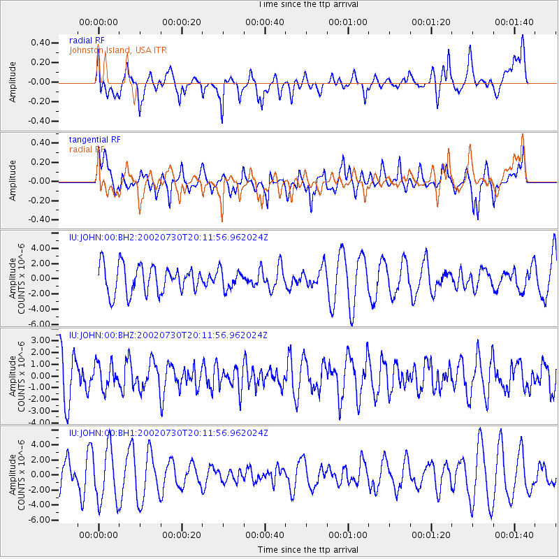
JOHN Johnston Island, USA - Earthquake Result Viewer
*The percent match for this event was below the threshold and hence no stack was calculated.
| Earthquake location: |
Banda Sea |
| Earthquake latitude/longitude: |
-6.5/130.3 |
| Earthquake time(UTC): |
2002/07/30 (211) 20:02:06 GMT |
| Earthquake Depth: |
103 km |
| Earthquake Magnitude: |
5.5 MW, 5.4 MB, 5.3 MW |
| Earthquake Catalog/Contributor: |
WHDF/NEIC |
|
| Network: |
IU Global Seismograph Network (GSN - IRIS/USGS) |
| Station: |
JOHN Johnston Island, USA |
| Lat/Lon: |
16.73 N/169.53 W |
| Elevation: |
2.0 m |
|
| Distance: |
63.8 deg |
| Az: |
67.872 deg |
| Baz: |
253.868 deg |
| Ray Param: |
$rayparam |
*The percent match for this event was below the threshold and hence was not used in the summary stack. |
|
| Radial Match: |
50.925232 % |
| Radial Bump: |
400 |
| Transverse Match: |
51.613716 % |
| Transverse Bump: |
400 |
| SOD ConfigId: |
590571 |
| Insert Time: |
2013-09-24 23:30:51.007 +0000 |
| GWidth: |
2.5 |
| Max Bumps: |
400 |
| Tol: |
0.001 |
|
Signal To Noise
| Channel | StoN | STA | LTA |
| IU:JOHN:00:BHZ:20020730T20:11:56.962024Z | 0.5655067 | 1.0903696E-6 | 1.9281285E-6 |
| IU:JOHN:00:BH1:20020730T20:11:56.962024Z | 2.999719 | 3.6678703E-6 | 1.222738E-6 |
| IU:JOHN:00:BH2:20020730T20:11:56.962024Z | 0.6843233 | 1.2570636E-6 | 1.8369439E-6 |
| Arrivals |
| Ps | |
| PpPs | |
| PsPs/PpSs | |


