You are here: Home > Network List > TA - USArray Transportable Network (new EarthScope stations) Stations List
> Station N40A Mertquake, Salem, IA, USA > Earthquake Result Viewer
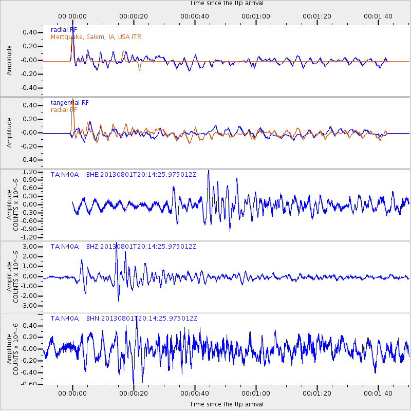
N40A Mertquake, Salem, IA, USA - Earthquake Result Viewer
*The percent match for this event was below the threshold and hence no stack was calculated.
| Earthquake location: |
Tonga Islands |
| Earthquake latitude/longitude: |
-15.2/-173.5 |
| Earthquake time(UTC): |
2013/08/01 (213) 20:01:43 GMT |
| Earthquake Depth: |
32 km |
| Earthquake Magnitude: |
6.0 MW, 5.8 MW, 5.9 MS, 6.1 MB |
| Earthquake Catalog/Contributor: |
NEIC PDE/NEIC PDE-W |
|
| Network: |
TA USArray Transportable Network (new EarthScope stations) |
| Station: |
N40A Mertquake, Salem, IA, USA |
| Lat/Lon: |
40.88 N/91.58 W |
| Elevation: |
208 m |
|
| Distance: |
93.9 deg |
| Az: |
48.798 deg |
| Baz: |
253.306 deg |
| Ray Param: |
$rayparam |
*The percent match for this event was below the threshold and hence was not used in the summary stack. |
|
| Radial Match: |
79.8016 % |
| Radial Bump: |
400 |
| Transverse Match: |
69.3244 % |
| Transverse Bump: |
400 |
| SOD ConfigId: |
589702 |
| Insert Time: |
2013-09-24 23:30:57.878 +0000 |
| GWidth: |
2.5 |
| Max Bumps: |
400 |
| Tol: |
0.001 |
|
Signal To Noise
| Channel | StoN | STA | LTA |
| TA:N40A: :BHZ:20130801T20:14:25.975012Z | 8.851823 | 7.3359087E-7 | 8.287455E-8 |
| TA:N40A: :BHN:20130801T20:14:25.975012Z | 1.6921499 | 1.3740413E-7 | 8.120092E-8 |
| TA:N40A: :BHE:20130801T20:14:25.975012Z | 2.4096112 | 3.0915345E-7 | 1.2830013E-7 |
| Arrivals |
| Ps | |
| PpPs | |
| PsPs/PpSs | |


