You are here: Home > Network List > TA - USArray Transportable Network (new EarthScope stations) Stations List
> Station WHTX Lake Whitney, Meridian, TX, USA > Earthquake Result Viewer
WHTX Lake Whitney, Meridian, TX, USA - Earthquake Result Viewer
| Earthquake location: |
Tonga Islands |
| Earthquake latitude/longitude: |
-15.2/-173.5 |
| Earthquake time(UTC): |
2013/08/01 (213) 20:01:43 GMT |
| Earthquake Depth: |
32 km |
| Earthquake Magnitude: |
6.0 MW, 5.8 MW, 5.9 MS, 6.1 MB |
| Earthquake Catalog/Contributor: |
NEIC PDE/NEIC PDE-W |
|
| Network: |
TA USArray Transportable Network (new EarthScope stations) |
| Station: |
WHTX Lake Whitney, Meridian, TX, USA |
| Lat/Lon: |
31.99 N/97.46 W |
| Elevation: |
190 m |
|
| Distance: |
86.6 deg |
| Az: |
55.703 deg |
| Baz: |
249.795 deg |
| Ray Param: |
0.043924913 |
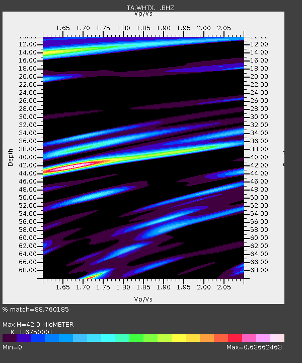
| Estimated Moho Depth: |
42.0 km |
| Estimated Crust Vp/Vs: |
1.68 |
| Assumed Crust Vp: |
6.347 km/s |
| Estimated Crust Vs: |
3.789 km/s |
| Estimated Crust Poisson's Ratio: |
0.22 |
|
| Radial Match: |
88.760185 % |
| Radial Bump: |
400 |
| Transverse Match: |
88.472786 % |
| Transverse Bump: |
400 |
| SOD ConfigId: |
589702 |
| Insert Time: |
2013-09-24 23:32:32.253 +0000 |
| GWidth: |
2.5 |
| Max Bumps: |
400 |
| Tol: |
0.001 |
|

Signal To Noise
| Channel | StoN | STA | LTA |
| TA:WHTX: :BHZ:20130801T20:13:51.850012Z | 13.789919 | 1.4737606E-6 | 1.0687232E-7 |
| TA:WHTX: :BHN:20130801T20:13:51.850012Z | 2.3175778 | 1.9245603E-7 | 8.304188E-8 |
| TA:WHTX: :BHE:20130801T20:13:51.850012Z | 4.4378633 | 4.214459E-7 | 9.496595E-8 |
| Arrivals |
| Ps | 4.6 SECOND |
| PpPs | 17 SECOND |
| PsPs/PpSs | 22 SECOND |


