You are here: Home > Network List > US - United States National Seismic Network Stations List
> Station DGMT Dagmar, Montana, USA > Earthquake Result Viewer
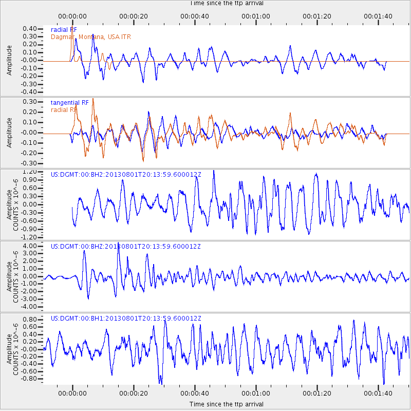
DGMT Dagmar, Montana, USA - Earthquake Result Viewer
*The percent match for this event was below the threshold and hence no stack was calculated.
| Earthquake location: |
Tonga Islands |
| Earthquake latitude/longitude: |
-15.2/-173.5 |
| Earthquake time(UTC): |
2013/08/01 (213) 20:01:43 GMT |
| Earthquake Depth: |
32 km |
| Earthquake Magnitude: |
6.0 MW, 5.8 MW, 5.9 MS, 6.1 MB |
| Earthquake Catalog/Contributor: |
NEIC PDE/NEIC PDE-W |
|
| Network: |
US United States National Seismic Network |
| Station: |
DGMT Dagmar, Montana, USA |
| Lat/Lon: |
48.47 N/104.20 W |
| Elevation: |
0.0 m |
|
| Distance: |
88.2 deg |
| Az: |
38.527 deg |
| Baz: |
244.614 deg |
| Ray Param: |
$rayparam |
*The percent match for this event was below the threshold and hence was not used in the summary stack. |
|
| Radial Match: |
75.55703 % |
| Radial Bump: |
400 |
| Transverse Match: |
72.28927 % |
| Transverse Bump: |
400 |
| SOD ConfigId: |
589702 |
| Insert Time: |
2013-09-24 23:33:46.290 +0000 |
| GWidth: |
2.5 |
| Max Bumps: |
400 |
| Tol: |
0.001 |
|
Signal To Noise
| Channel | StoN | STA | LTA |
| US:DGMT:00:BHZ:20130801T20:13:59.600012Z | 9.799041 | 1.3728247E-6 | 1.4009787E-7 |
| US:DGMT:00:BH1:20130801T20:13:59.600012Z | 0.6723592 | 1.600805E-7 | 2.3808775E-7 |
| US:DGMT:00:BH2:20130801T20:13:59.600012Z | 0.7857677 | 2.768617E-7 | 3.523455E-7 |
| Arrivals |
| Ps | |
| PpPs | |
| PsPs/PpSs | |


