You are here: Home > Network List > IU - Global Seismograph Network (GSN - IRIS/USGS) Stations List
> Station RSSD Black Hills, South Dakota, USA > Earthquake Result Viewer
RSSD Black Hills, South Dakota, USA - Earthquake Result Viewer
*The percent match for this event was below the threshold and hence no stack was calculated.
| Earthquake location: |
Fiji Islands Region |
| Earthquake latitude/longitude: |
-21.9/-176.6 |
| Earthquake time(UTC): |
2002/08/07 (219) 04:50:06 GMT |
| Earthquake Depth: |
174 km |
| Earthquake Magnitude: |
5.4 MB, 5.8 MW, 5.7 MW |
| Earthquake Catalog/Contributor: |
WHDF/NEIC |
|
| Network: |
IU Global Seismograph Network (GSN - IRIS/USGS) |
| Station: |
RSSD Black Hills, South Dakota, USA |
| Lat/Lon: |
44.12 N/104.04 W |
| Elevation: |
2060 m |
|
| Distance: |
93.2 deg |
| Az: |
43.483 deg |
| Baz: |
242.567 deg |
| Ray Param: |
$rayparam |
*The percent match for this event was below the threshold and hence was not used in the summary stack. |
|
| Radial Match: |
69.92602 % |
| Radial Bump: |
400 |
| Transverse Match: |
62.657593 % |
| Transverse Bump: |
400 |
| SOD ConfigId: |
590571 |
| Insert Time: |
2013-09-24 23:34:40.131 +0000 |
| GWidth: |
2.5 |
| Max Bumps: |
400 |
| Tol: |
0.001 |
|
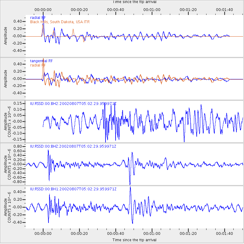
Signal To Noise
| Channel | StoN | STA | LTA |
| IU:RSSD:00:BHZ:20020807T05:02:29.959971Z | 5.7993813 | 2.6121725E-7 | 4.5042263E-8 |
| IU:RSSD:00:BH1:20020807T05:02:29.959971Z | 3.6701024 | 1.3579134E-7 | 3.699933E-8 |
| IU:RSSD:00:BH2:20020807T05:02:29.959971Z | 1.5704241 | 6.4779385E-8 | 4.1249614E-8 |
| Arrivals |
| Ps | |
| PpPs | |
| PsPs/PpSs | |


