You are here: Home > Network List > UU - University of Utah Regional Network Stations List
> Station BRPU Butcher Ranch, Price, UT, USA old TA-P17A > Earthquake Result Viewer
BRPU Butcher Ranch, Price, UT, USA old TA-P17A - Earthquake Result Viewer
| Earthquake location: |
Tonga Islands |
| Earthquake latitude/longitude: |
-15.2/-173.5 |
| Earthquake time(UTC): |
2013/08/01 (213) 20:01:43 GMT |
| Earthquake Depth: |
32 km |
| Earthquake Magnitude: |
6.0 MW, 5.8 MW, 5.9 MS, 6.1 MB |
| Earthquake Catalog/Contributor: |
NEIC PDE/NEIC PDE-W |
|
| Network: |
UU University of Utah Regional Network |
| Station: |
BRPU Butcher Ranch, Price, UT, USA old TA-P17A |
| Lat/Lon: |
39.47 N/110.74 W |
| Elevation: |
1687 m |
|
| Distance: |
79.8 deg |
| Az: |
44.36 deg |
| Baz: |
240.681 deg |
| Ray Param: |
0.04864807 |
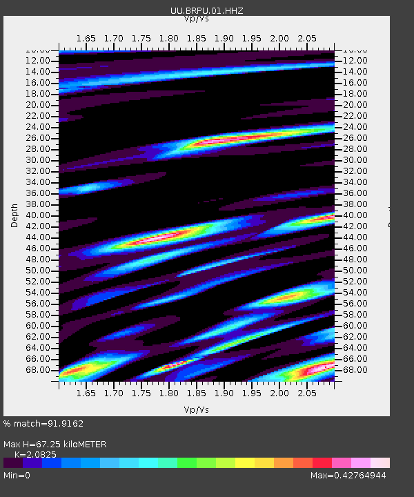
| Estimated Moho Depth: |
67.25 km |
| Estimated Crust Vp/Vs: |
2.08 |
| Assumed Crust Vp: |
6.207 km/s |
| Estimated Crust Vs: |
2.98 km/s |
| Estimated Crust Poisson's Ratio: |
0.35 |
|
| Radial Match: |
91.9162 % |
| Radial Bump: |
400 |
| Transverse Match: |
82.85625 % |
| Transverse Bump: |
400 |
| SOD ConfigId: |
589702 |
| Insert Time: |
2013-09-24 23:35:05.114 +0000 |
| GWidth: |
2.5 |
| Max Bumps: |
400 |
| Tol: |
0.001 |
|

Signal To Noise
| Channel | StoN | STA | LTA |
| UU:BRPU:01:HHZ:20130801T20:13:17.31803Z | 20.41681 | 4.2205908E-8 | 2.0672137E-9 |
| UU:BRPU:01:HHN:20130801T20:13:17.31803Z | 2.8214629 | 5.46059E-9 | 1.9353756E-9 |
| UU:BRPU:01:HHE:20130801T20:13:17.31803Z | 7.595754 | 1.0960009E-8 | 1.4429126E-9 |
| Arrivals |
| Ps | 12 SECOND |
| PpPs | 33 SECOND |
| PsPs/PpSs | 45 SECOND |


