You are here: Home > Network List > UU - University of Utah Regional Network Stations List
> Station HVU Hansel Valley, UT, USA > Earthquake Result Viewer
HVU Hansel Valley, UT, USA - Earthquake Result Viewer

| Earthquake location: |
Tonga Islands |
| Earthquake latitude/longitude: |
-15.2/-173.5 |
| Earthquake time(UTC): |
2013/08/01 (213) 20:01:43 GMT |
| Earthquake Depth: |
32 km |
| Earthquake Magnitude: |
6.0 MW, 5.8 MW, 5.9 MS, 6.1 MB |
| Earthquake Catalog/Contributor: |
NEIC PDE/NEIC PDE-W |
|
| Network: |
UU University of Utah Regional Network |
| Station: |
HVU Hansel Valley, UT, USA |
| Lat/Lon: |
41.78 N/112.78 W |
| Elevation: |
1609 m |
|
| Distance: |
79.7 deg |
| Az: |
41.544 deg |
| Baz: |
238.86 deg |
| Ray Param: |
0.048770066 |
| Estimated Moho Depth: |
45.75 km |
| Estimated Crust Vp/Vs: |
1.89 |
| Assumed Crust Vp: |
6.276 km/s |
| Estimated Crust Vs: |
3.312 km/s |
| Estimated Crust Poisson's Ratio: |
0.31 |
|
| Radial Match: |
89.04166 % |
| Radial Bump: |
400 |
| Transverse Match: |
85.821434 % |
| Transverse Bump: |
400 |
| SOD ConfigId: |
589702 |
| Insert Time: |
2013-09-24 23:35:19.567 +0000 |
| GWidth: |
2.5 |
| Max Bumps: |
400 |
| Tol: |
0.001 |
|
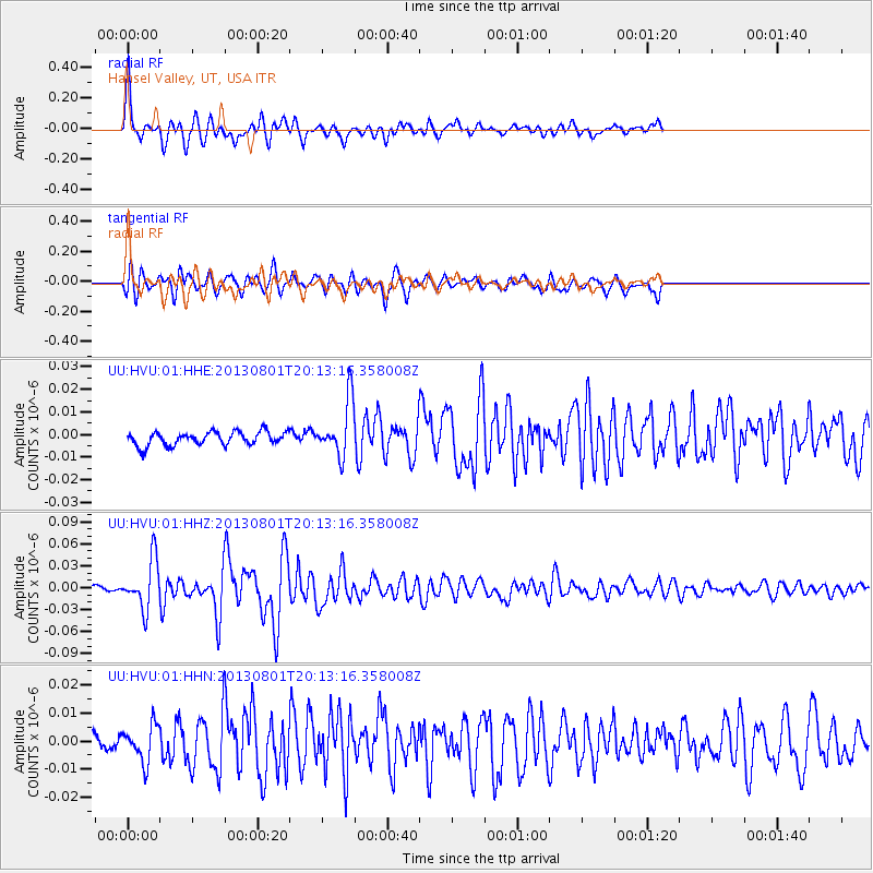
Signal To Noise
| Channel | StoN | STA | LTA |
| UU:HVU:01:HHZ:20130801T20:13:16.358008Z | 14.114369 | 3.337503E-8 | 2.3646136E-9 |
| UU:HVU:01:HHN:20130801T20:13:16.358008Z | 2.909791 | 6.5111636E-9 | 2.237674E-9 |
| UU:HVU:01:HHE:20130801T20:13:16.358008Z | 4.1095552 | 1.2244321E-8 | 2.9794762E-9 |
| Arrivals |
| Ps | 6.7 SECOND |
| PpPs | 21 SECOND |
| PsPs/PpSs | 27 SECOND |


