You are here: Home > Network List > UU - University of Utah Regional Network Stations List
> Station KNB Kanab, UT, USA > Earthquake Result Viewer
KNB Kanab, UT, USA - Earthquake Result Viewer
| Earthquake location: |
Tonga Islands |
| Earthquake latitude/longitude: |
-15.2/-173.5 |
| Earthquake time(UTC): |
2013/08/01 (213) 20:01:43 GMT |
| Earthquake Depth: |
32 km |
| Earthquake Magnitude: |
6.0 MW, 5.8 MW, 5.9 MS, 6.1 MB |
| Earthquake Catalog/Contributor: |
NEIC PDE/NEIC PDE-W |
|
| Network: |
UU University of Utah Regional Network |
| Station: |
KNB Kanab, UT, USA |
| Lat/Lon: |
37.02 N/112.82 W |
| Elevation: |
1715 m |
|
| Distance: |
77.2 deg |
| Az: |
45.698 deg |
| Baz: |
239.664 deg |
| Ray Param: |
0.05044659 |
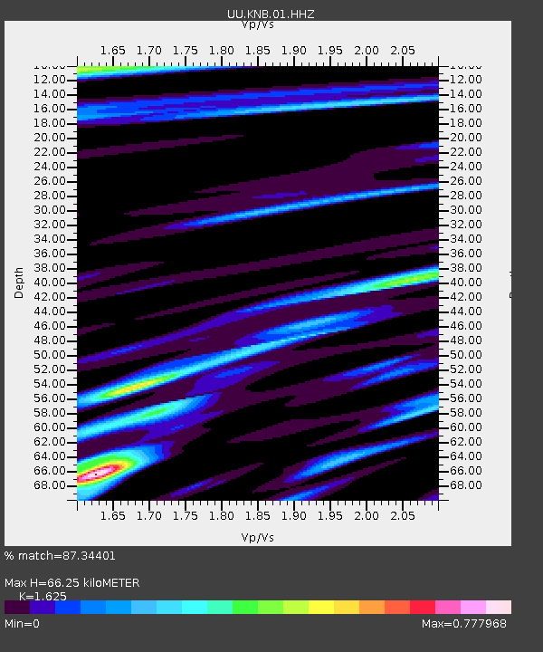
| Estimated Moho Depth: |
66.25 km |
| Estimated Crust Vp/Vs: |
1.62 |
| Assumed Crust Vp: |
6.194 km/s |
| Estimated Crust Vs: |
3.812 km/s |
| Estimated Crust Poisson's Ratio: |
0.20 |
|
| Radial Match: |
87.34401 % |
| Radial Bump: |
400 |
| Transverse Match: |
82.7622 % |
| Transverse Bump: |
330 |
| SOD ConfigId: |
589702 |
| Insert Time: |
2013-09-24 23:35:24.974 +0000 |
| GWidth: |
2.5 |
| Max Bumps: |
400 |
| Tol: |
0.001 |
|

Signal To Noise
| Channel | StoN | STA | LTA |
| UU:KNB:01:HHZ:20130801T20:13:02.790015Z | 17.686214 | 5.0413533E-8 | 2.850442E-9 |
| UU:KNB:01:HHN:20130801T20:13:02.790015Z | 2.2554173 | 5.404024E-9 | 2.3960196E-9 |
| UU:KNB:01:HHE:20130801T20:13:02.790015Z | 3.6655169 | 1.35892195E-8 | 3.7073133E-9 |
| Arrivals |
| Ps | 6.9 SECOND |
| PpPs | 27 SECOND |
| PsPs/PpSs | 34 SECOND |


