You are here: Home > Network List > UW - Pacific Northwest Regional Seismic Network Stations List
> Station LEBA Lebam, WA, USA > Earthquake Result Viewer
LEBA Lebam, WA, USA - Earthquake Result Viewer
| Earthquake location: |
Tonga Islands |
| Earthquake latitude/longitude: |
-15.2/-173.5 |
| Earthquake time(UTC): |
2013/08/01 (213) 20:01:43 GMT |
| Earthquake Depth: |
32 km |
| Earthquake Magnitude: |
6.0 MW, 5.8 MW, 5.9 MS, 6.1 MB |
| Earthquake Catalog/Contributor: |
NEIC PDE/NEIC PDE-W |
|
| Network: |
UW Pacific Northwest Regional Seismic Network |
| Station: |
LEBA Lebam, WA, USA |
| Lat/Lon: |
46.55 N/123.56 W |
| Elevation: |
73 m |
|
| Distance: |
76.1 deg |
| Az: |
32.964 deg |
| Baz: |
229.548 deg |
| Ray Param: |
0.05115747 |
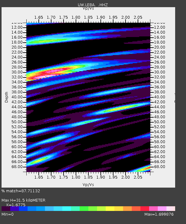
| Estimated Moho Depth: |
31.5 km |
| Estimated Crust Vp/Vs: |
1.68 |
| Assumed Crust Vp: |
6.566 km/s |
| Estimated Crust Vs: |
3.914 km/s |
| Estimated Crust Poisson's Ratio: |
0.22 |
|
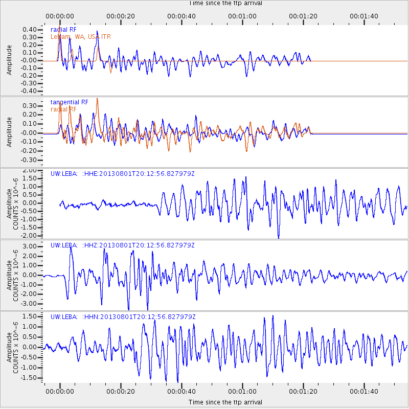
| Radial Match: |
87.71132 % |
| Radial Bump: |
400 |
| Transverse Match: |
81.72966 % |
| Transverse Bump: |
400 |
| SOD ConfigId: |
589702 |
| Insert Time: |
2013-09-24 23:36:44.583 +0000 |
| GWidth: |
2.5 |
| Max Bumps: |
400 |
| Tol: |
0.001 |
|
Signal To Noise
| Channel | StoN | STA | LTA |
| UW:LEBA: :HHZ:20130801T20:12:56.827979Z | 19.229095 | 1.3680122E-6 | 7.1142836E-8 |
| UW:LEBA: :HHN:20130801T20:12:56.827979Z | 2.1768913 | 2.3931247E-7 | 1.0993311E-7 |
| UW:LEBA: :HHE:20130801T20:12:56.827979Z | 3.0787435 | 3.3462274E-7 | 1.08688084E-7 |
| Arrivals |
| Ps | 3.4 SECOND |
| PpPs | 12 SECOND |
| PsPs/PpSs | 16 SECOND |


