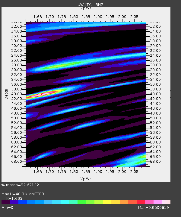
LTY Liberty (broad-band) - Earthquake Result Viewer
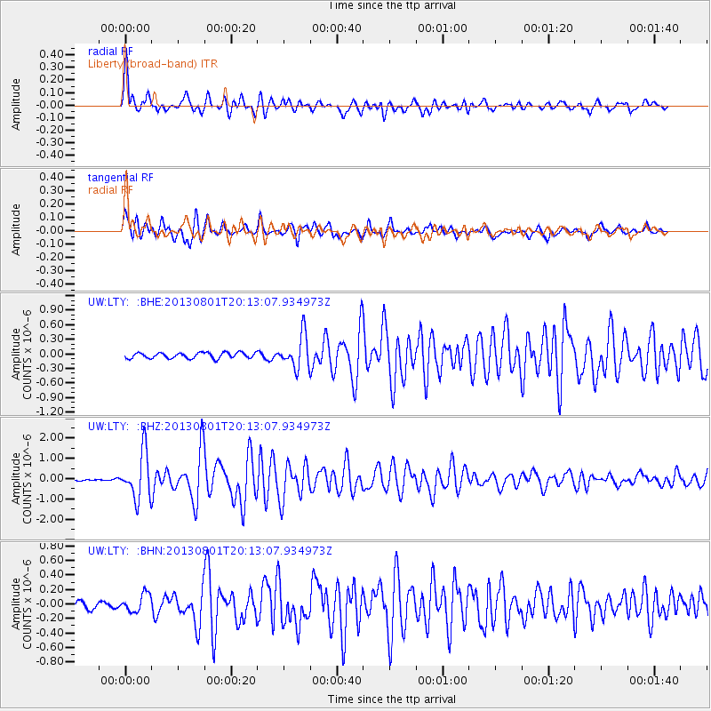
Earthquake location: Tonga Islands
Earthquake latitude/longitude: -15.2/-173.5
Earthquake time(UTC): 2013/08/01 (213) 20:01:43 GMT
Earthquake Depth: 32 km
Earthquake Magnitude: 6.0 MW, 5.8 MW, 5.9 MS, 6.1 MB
Earthquake Catalog/Contributor: NEIC PDE/NEIC PDE-W
Network: UW Pacific Northwest Regional Seismic Network
Station: LTY Liberty (broad-band)
Lat/Lon: 47.26 N/120.66 W
Elevation: 970 m
Distance: 78.1 deg
Az: 33.692 deg
Baz: 231.82 deg
Ray Param: 0.04981684
Estimated Moho Depth: 40.0 km
Estimated Crust Vp/Vs: 1.66
Assumed Crust Vp: 6.597 km/s
Estimated Crust Vs: 3.962 km/s
Estimated Crust Poisson's Ratio: 0.22
Radial Match: 92.67132 %
Radial Bump: 400
Transverse Match: 89.57283 %
Transverse Bump: 400
SOD ConfigId: 589702
Insert Time: 2013-09-24 23:36:52.318 +0000
GWidth: 2.5
Max Bumps: 400
Tol: 0.001

Signal To Noise

ChannelStoNSTALTA
UW:LTY: :BHZ:20130801T20:13:07.934973Z23.4846881.1641395E-64.957015E-8
UW:LTY: :BHN:20130801T20:13:07.934973Z2.23357061.2514619E-75.6029656E-8
UW:LTY: :BHE:20130801T20:13:07.934973Z5.90876773.4647064E-75.86367E-8
Arrivals
Ps4.2 SECOND
PpPs16 SECOND
PsPs/PpSs20 SECOND