You are here: Home > Network List > NE - New England Seismic Network Stations List
> Station EMMW Machias, ME, USA > Earthquake Result Viewer
EMMW Machias, ME, USA - Earthquake Result Viewer
*The percent match for this event was below the threshold and hence no stack was calculated.
| Earthquake location: |
Easter Island Region |
| Earthquake latitude/longitude: |
-26.8/-114.3 |
| Earthquake time(UTC): |
2014/09/21 (264) 15:45:20 GMT |
| Earthquake Depth: |
10 km |
| Earthquake Magnitude: |
5.2 MW |
| Earthquake Catalog/Contributor: |
ISC/ISC |
|
| Network: |
NE New England Seismic Network |
| Station: |
EMMW Machias, ME, USA |
| Lat/Lon: |
44.71 N/67.46 W |
| Elevation: |
35 m |
|
| Distance: |
83.0 deg |
| Az: |
31.594 deg |
| Baz: |
221.038 deg |
| Ray Param: |
$rayparam |
*The percent match for this event was below the threshold and hence was not used in the summary stack. |
|
| Radial Match: |
64.045944 % |
| Radial Bump: |
400 |
| Transverse Match: |
43.081444 % |
| Transverse Bump: |
400 |
| SOD ConfigId: |
3390531 |
| Insert Time: |
2019-04-14 03:48:38.873 +0000 |
| GWidth: |
2.5 |
| Max Bumps: |
400 |
| Tol: |
0.001 |
|
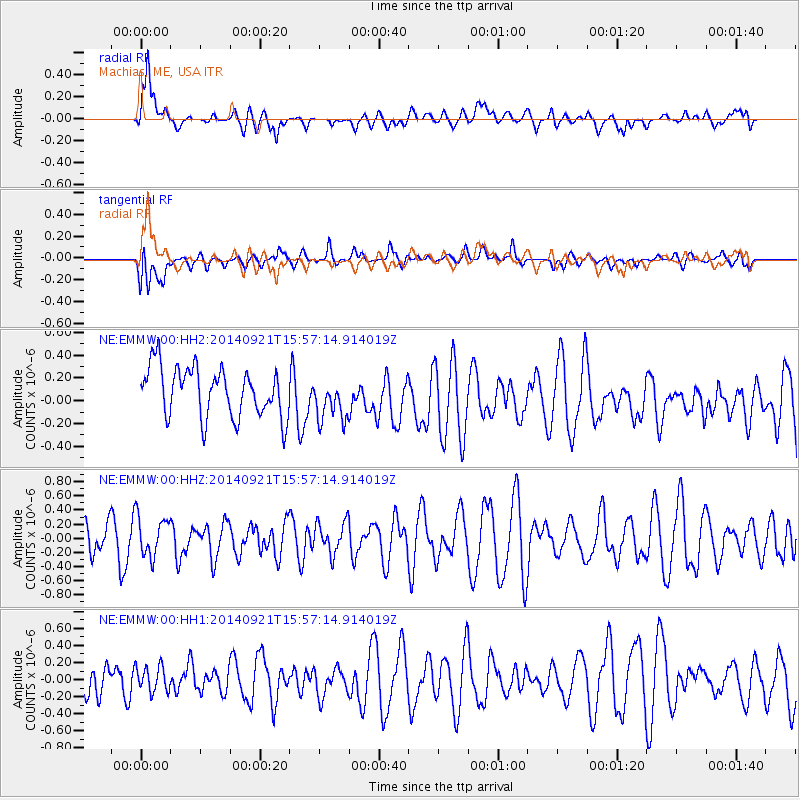
Signal To Noise
| Channel | StoN | STA | LTA |
| NE:EMMW:00:HHZ:20140921T15:57:14.914019Z | 0.81709975 | 2.7978106E-7 | 3.4240745E-7 |
| NE:EMMW:00:HH1:20140921T15:57:14.914019Z | 0.5469614 | 1.4652726E-7 | 2.6789323E-7 |
| NE:EMMW:00:HH2:20140921T15:57:14.914019Z | 0.89075285 | 1.931036E-7 | 2.1678696E-7 |
| Arrivals |
| Ps | |
| PpPs | |
| PsPs/PpSs | |


