You are here: Home > Network List > IU - Global Seismograph Network (GSN - IRIS/USGS) Stations List
> Station JOHN Johnston Island, USA > Earthquake Result Viewer
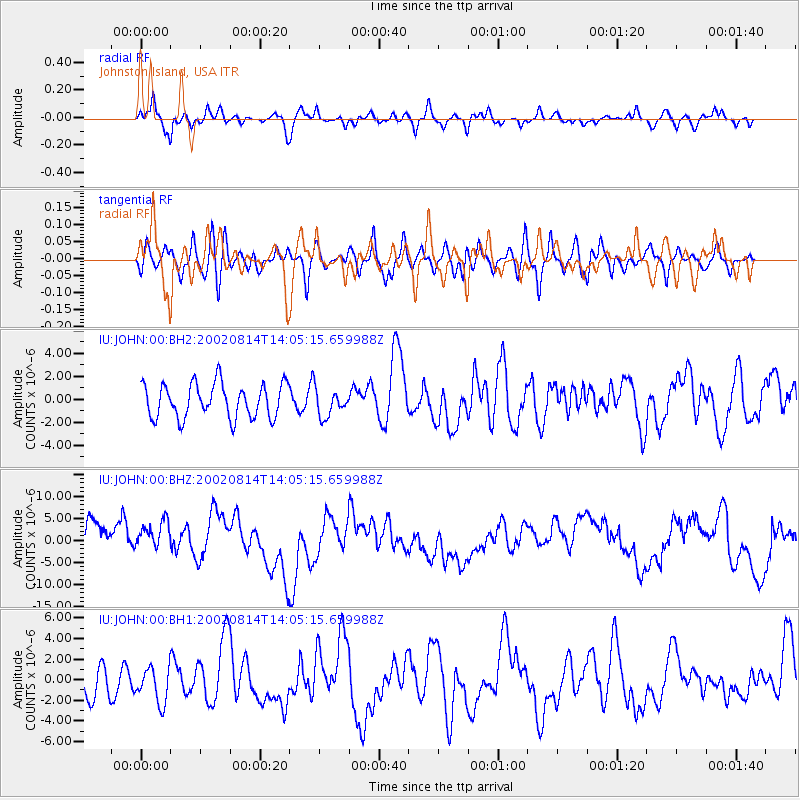
JOHN Johnston Island, USA - Earthquake Result Viewer
*The percent match for this event was below the threshold and hence no stack was calculated.
| Earthquake location: |
Mariana Islands |
| Earthquake latitude/longitude: |
14.1/146.2 |
| Earthquake time(UTC): |
2002/08/14 (226) 13:57:52 GMT |
| Earthquake Depth: |
30 km |
| Earthquake Magnitude: |
6.1 MB, 6.4 MS, 6.5 MW, 6.4 MW |
| Earthquake Catalog/Contributor: |
WHDF/NEIC |
|
| Network: |
IU Global Seismograph Network (GSN - IRIS/USGS) |
| Station: |
JOHN Johnston Island, USA |
| Lat/Lon: |
16.73 N/169.53 W |
| Elevation: |
2.0 m |
|
| Distance: |
42.7 deg |
| Az: |
80.534 deg |
| Baz: |
272.805 deg |
| Ray Param: |
$rayparam |
*The percent match for this event was below the threshold and hence was not used in the summary stack. |
|
| Radial Match: |
59.364437 % |
| Radial Bump: |
378 |
| Transverse Match: |
43.766987 % |
| Transverse Bump: |
400 |
| SOD ConfigId: |
590571 |
| Insert Time: |
2013-09-24 23:39:37.769 +0000 |
| GWidth: |
2.5 |
| Max Bumps: |
400 |
| Tol: |
0.001 |
|
Signal To Noise
| Channel | StoN | STA | LTA |
| IU:JOHN:00:BHZ:20020814T14:05:15.659988Z | 1.212152 | 5.1716365E-6 | 4.266492E-6 |
| IU:JOHN:00:BH1:20020814T14:05:15.659988Z | 0.78019726 | 1.6900287E-6 | 2.1661558E-6 |
| IU:JOHN:00:BH2:20020814T14:05:15.659988Z | 0.8024626 | 1.1947469E-6 | 1.4888507E-6 |
| Arrivals |
| Ps | |
| PpPs | |
| PsPs/PpSs | |


