You are here: Home > Network List > TA - USArray Transportable Network (new EarthScope stations) Stations List
> Station I61A Oroboro, Fairlee, VT, USA > Earthquake Result Viewer
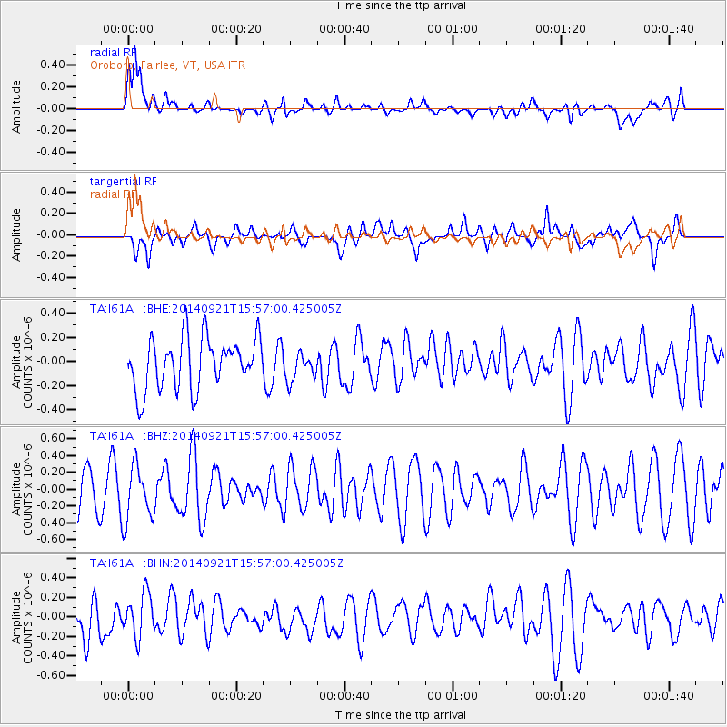
I61A Oroboro, Fairlee, VT, USA - Earthquake Result Viewer
*The percent match for this event was below the threshold and hence no stack was calculated.
| Earthquake location: |
Easter Island Region |
| Earthquake latitude/longitude: |
-26.8/-114.3 |
| Earthquake time(UTC): |
2014/09/21 (264) 15:45:20 GMT |
| Earthquake Depth: |
10 km |
| Earthquake Magnitude: |
5.2 MW |
| Earthquake Catalog/Contributor: |
ISC/ISC |
|
| Network: |
TA USArray Transportable Network (new EarthScope stations) |
| Station: |
I61A Oroboro, Fairlee, VT, USA |
| Lat/Lon: |
43.93 N/72.21 W |
| Elevation: |
287 m |
|
| Distance: |
80.3 deg |
| Az: |
29.419 deg |
| Baz: |
217.413 deg |
| Ray Param: |
$rayparam |
*The percent match for this event was below the threshold and hence was not used in the summary stack. |
|
| Radial Match: |
59.634624 % |
| Radial Bump: |
400 |
| Transverse Match: |
36.469513 % |
| Transverse Bump: |
400 |
| SOD ConfigId: |
3390531 |
| Insert Time: |
2019-04-14 03:50:07.282 +0000 |
| GWidth: |
2.5 |
| Max Bumps: |
400 |
| Tol: |
0.001 |
|
Signal To Noise
| Channel | StoN | STA | LTA |
| TA:I61A: :BHZ:20140921T15:57:00.425005Z | 1.4554701 | 3.241595E-7 | 2.2271806E-7 |
| TA:I61A: :BHN:20140921T15:57:00.425005Z | 0.7739519 | 2.265652E-7 | 2.927381E-7 |
| TA:I61A: :BHE:20140921T15:57:00.425005Z | 0.5551133 | 1.1844662E-7 | 2.1337377E-7 |
| Arrivals |
| Ps | |
| PpPs | |
| PsPs/PpSs | |


