You are here: Home > Network List > TA - USArray Transportable Network (new EarthScope stations) Stations List
> Station R56A Bull Pasture Mountain, McDowell, VA, USA > Earthquake Result Viewer
R56A Bull Pasture Mountain, McDowell, VA, USA - Earthquake Result Viewer
*The percent match for this event was below the threshold and hence no stack was calculated.
| Earthquake location: |
Easter Island Region |
| Earthquake latitude/longitude: |
-26.8/-114.3 |
| Earthquake time(UTC): |
2014/09/21 (264) 15:45:20 GMT |
| Earthquake Depth: |
10 km |
| Earthquake Magnitude: |
5.2 MW |
| Earthquake Catalog/Contributor: |
ISC/ISC |
|
| Network: |
TA USArray Transportable Network (new EarthScope stations) |
| Station: |
R56A Bull Pasture Mountain, McDowell, VA, USA |
| Lat/Lon: |
38.41 N/79.40 W |
| Elevation: |
902 m |
|
| Distance: |
72.6 deg |
| Az: |
28.08 deg |
| Baz: |
212.371 deg |
| Ray Param: |
$rayparam |
*The percent match for this event was below the threshold and hence was not used in the summary stack. |
|
| Radial Match: |
57.703148 % |
| Radial Bump: |
400 |
| Transverse Match: |
68.58397 % |
| Transverse Bump: |
400 |
| SOD ConfigId: |
3390531 |
| Insert Time: |
2019-04-14 03:50:33.132 +0000 |
| GWidth: |
2.5 |
| Max Bumps: |
400 |
| Tol: |
0.001 |
|
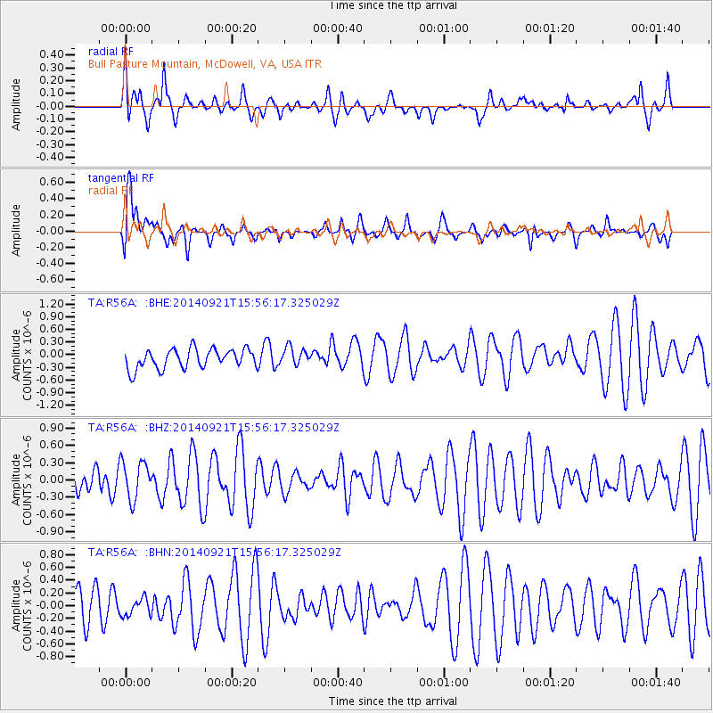
Signal To Noise
| Channel | StoN | STA | LTA |
| TA:R56A: :BHZ:20140921T15:56:17.325029Z | 1.5695462 | 3.2453792E-7 | 2.0677183E-7 |
| TA:R56A: :BHN:20140921T15:56:17.325029Z | 0.47992563 | 1.3649957E-7 | 2.8441818E-7 |
| TA:R56A: :BHE:20140921T15:56:17.325029Z | 0.91705376 | 2.0992984E-7 | 2.2891771E-7 |
| Arrivals |
| Ps | |
| PpPs | |
| PsPs/PpSs | |


