You are here: Home > Network List > TA - USArray Transportable Network (new EarthScope stations) Stations List
> Station W41B Gary Mavity, Velonia, AR, USA > Earthquake Result Viewer
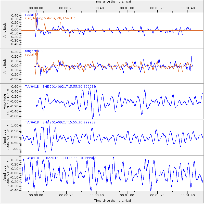
W41B Gary Mavity, Velonia, AR, USA - Earthquake Result Viewer
*The percent match for this event was below the threshold and hence no stack was calculated.
| Earthquake location: |
Easter Island Region |
| Earthquake latitude/longitude: |
-26.8/-114.3 |
| Earthquake time(UTC): |
2014/09/21 (264) 15:45:20 GMT |
| Earthquake Depth: |
10 km |
| Earthquake Magnitude: |
5.2 MW |
| Earthquake Catalog/Contributor: |
ISC/ISC |
|
| Network: |
TA USArray Transportable Network (new EarthScope stations) |
| Station: |
W41B Gary Mavity, Velonia, AR, USA |
| Lat/Lon: |
35.17 N/92.25 W |
| Elevation: |
95 m |
|
| Distance: |
65.1 deg |
| Az: |
19.809 deg |
| Baz: |
201.695 deg |
| Ray Param: |
$rayparam |
*The percent match for this event was below the threshold and hence was not used in the summary stack. |
|
| Radial Match: |
66.293526 % |
| Radial Bump: |
400 |
| Transverse Match: |
61.874283 % |
| Transverse Bump: |
400 |
| SOD ConfigId: |
3390531 |
| Insert Time: |
2019-04-14 03:50:42.356 +0000 |
| GWidth: |
2.5 |
| Max Bumps: |
400 |
| Tol: |
0.001 |
|
Signal To Noise
| Channel | StoN | STA | LTA |
| TA:W41B: :BHZ:20140921T15:55:30.39998Z | 3.347035 | 6.928196E-7 | 2.0699503E-7 |
| TA:W41B: :BHN:20140921T15:55:30.39998Z | 1.3458688 | 1.9923525E-7 | 1.4803467E-7 |
| TA:W41B: :BHE:20140921T15:55:30.39998Z | 2.1984792 | 2.8674538E-7 | 1.3042896E-7 |
| Arrivals |
| Ps | |
| PpPs | |
| PsPs/PpSs | |


