You are here: Home > Network List > IU - Global Seismograph Network (GSN - IRIS/USGS) Stations List
> Station RSSD Black Hills, South Dakota, USA > Earthquake Result Viewer
RSSD Black Hills, South Dakota, USA - Earthquake Result Viewer

| Earthquake location: |
Fiji Islands Region |
| Earthquake latitude/longitude: |
-21.7/-179.5 |
| Earthquake time(UTC): |
2002/08/19 (231) 11:01:01 GMT |
| Earthquake Depth: |
580 km |
| Earthquake Magnitude: |
6.7 MB, 7.6 MW, 7.7 ME |
| Earthquake Catalog/Contributor: |
WHDF/NEIC |
|
| Network: |
IU Global Seismograph Network (GSN - IRIS/USGS) |
| Station: |
RSSD Black Hills, South Dakota, USA |
| Lat/Lon: |
44.12 N/104.04 W |
| Elevation: |
2060 m |
|
| Distance: |
95.0 deg |
| Az: |
44.415 deg |
| Baz: |
244.651 deg |
| Ray Param: |
0.040305156 |
| Estimated Moho Depth: |
58.0 km |
| Estimated Crust Vp/Vs: |
1.67 |
| Assumed Crust Vp: |
6.242 km/s |
| Estimated Crust Vs: |
3.732 km/s |
| Estimated Crust Poisson's Ratio: |
0.22 |
|
| Radial Match: |
95.83169 % |
| Radial Bump: |
400 |
| Transverse Match: |
85.347046 % |
| Transverse Bump: |
400 |
| SOD ConfigId: |
590571 |
| Insert Time: |
2013-09-24 23:41:11.045 +0000 |
| GWidth: |
2.5 |
| Max Bumps: |
400 |
| Tol: |
0.001 |
|
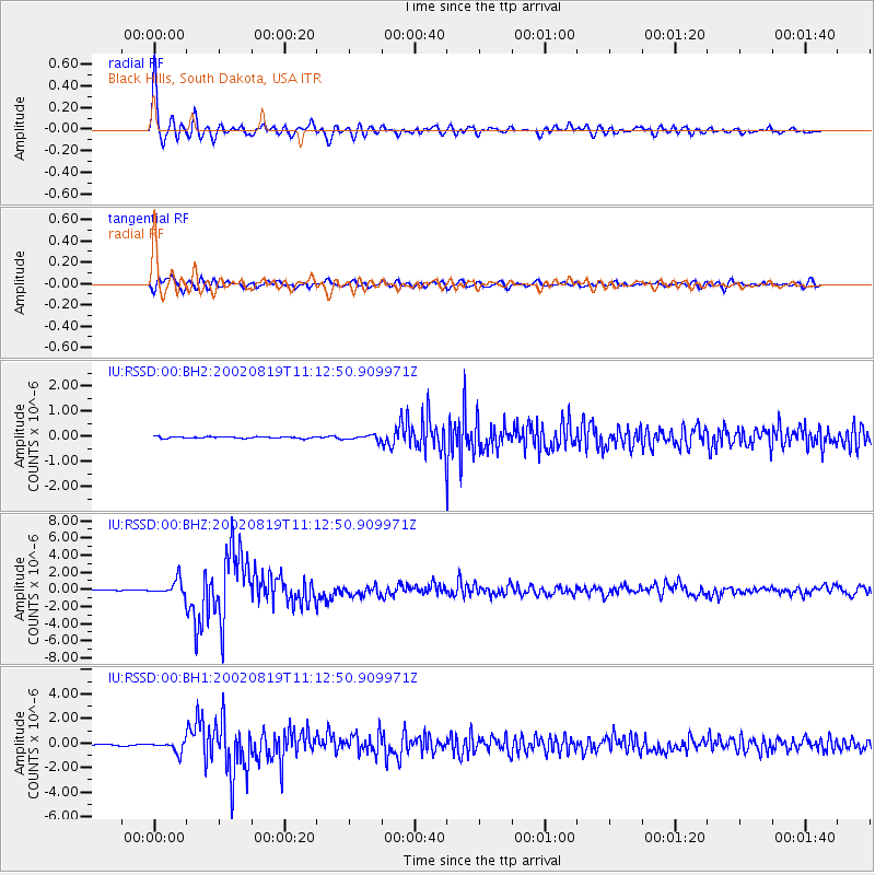
Signal To Noise
| Channel | StoN | STA | LTA |
| IU:RSSD:00:BHZ:20020819T11:12:50.909971Z | 24.191307 | 8.925764E-7 | 3.6896576E-8 |
| IU:RSSD:00:BH1:20020819T11:12:50.909971Z | 8.574153 | 4.451612E-7 | 5.191897E-8 |
| IU:RSSD:00:BH2:20020819T11:12:50.909971Z | 3.027107 | 9.897352E-8 | 3.269575E-8 |
| Arrivals |
| Ps | 6.4 SECOND |
| PpPs | 24 SECOND |
| PsPs/PpSs | 31 SECOND |


