You are here: Home > Network List > GS - US Geological Survey Networks Stations List
> Station KAN09 Caldwell North Station > Earthquake Result Viewer
KAN09 Caldwell North Station - Earthquake Result Viewer
| Earthquake location: |
Bonin Islands, Japan Region |
| Earthquake latitude/longitude: |
27.9/139.6 |
| Earthquake time(UTC): |
2014/09/21 (264) 17:32:05 GMT |
| Earthquake Depth: |
491 km |
| Earthquake Magnitude: |
5.5 MWW |
| Earthquake Catalog/Contributor: |
NEIC PDE/NEIC COMCAT |
|
| Network: |
GS US Geological Survey Networks |
| Station: |
KAN09 Caldwell North Station |
| Lat/Lon: |
37.14 N/97.62 W |
| Elevation: |
371 m |
|
| Distance: |
95.9 deg |
| Az: |
42.487 deg |
| Baz: |
311.603 deg |
| Ray Param: |
0.040161155 |
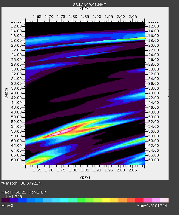
| Estimated Moho Depth: |
56.25 km |
| Estimated Crust Vp/Vs: |
1.75 |
| Assumed Crust Vp: |
6.483 km/s |
| Estimated Crust Vs: |
3.715 km/s |
| Estimated Crust Poisson's Ratio: |
0.26 |
|
| Radial Match: |
86.679214 % |
| Radial Bump: |
400 |
| Transverse Match: |
98.25248 % |
| Transverse Bump: |
75 |
| SOD ConfigId: |
3390531 |
| Insert Time: |
2019-04-14 03:55:31.556 +0000 |
| GWidth: |
2.5 |
| Max Bumps: |
400 |
| Tol: |
0.001 |
|

Signal To Noise
| Channel | StoN | STA | LTA |
| GS:KAN09:01:HHZ:20140921T17:44:06.455007Z | 2.2162719 | 2.81013E-6 | 1.2679536E-6 |
| GS:KAN09:01:HHN:20140921T17:44:06.455007Z | 2.7916327 | 1.5657873E-6 | 5.608859E-7 |
| GS:KAN09:01:HHE:20140921T17:44:06.455007Z | 2.9085507 | 6.2656604E-6 | 2.1542207E-6 |
| Arrivals |
| Ps | 6.6 SECOND |
| PpPs | 23 SECOND |
| PsPs/PpSs | 30 SECOND |


