You are here: Home > Network List > CN - Canadian National Seismograph Network Stations List
> Station SCHQ Schefferville, PQ > Earthquake Result Viewer
SCHQ Schefferville, PQ - Earthquake Result Viewer
| Earthquake location: |
Near Coast Of Peru |
| Earthquake latitude/longitude: |
-15.0/-75.7 |
| Earthquake time(UTC): |
1996/11/12 (317) 16:59:44 GMT |
| Earthquake Depth: |
33 km |
| Earthquake Magnitude: |
6.5 MB, 7.3 MS, 7.7 UNKNOWN, 7.7 MW |
| Earthquake Catalog/Contributor: |
WHDF/NEIC |
|
| Network: |
CN Canadian National Seismograph Network |
| Station: |
SCHQ Schefferville, PQ |
| Lat/Lon: |
54.83 N/66.83 W |
| Elevation: |
501 m |
|
| Distance: |
70.0 deg |
| Az: |
5.432 deg |
| Baz: |
189.097 deg |
| Ray Param: |
0.055254005 |
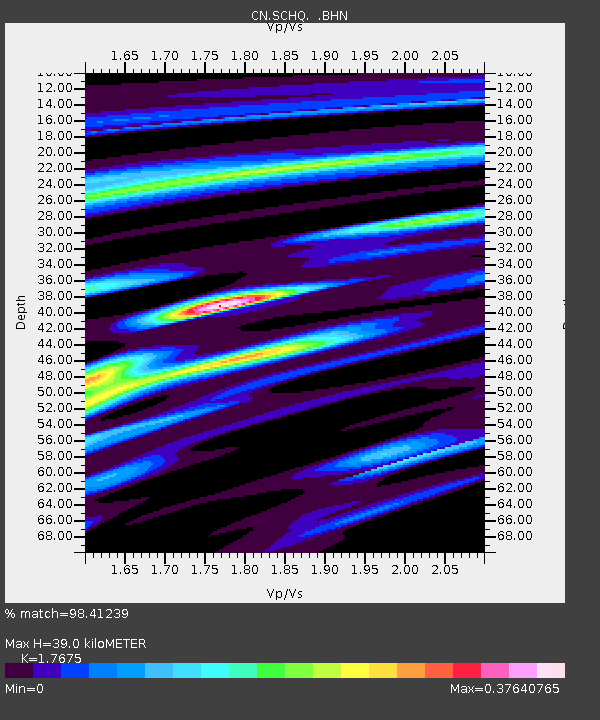
| Estimated Moho Depth: |
39.0 km |
| Estimated Crust Vp/Vs: |
1.77 |
| Assumed Crust Vp: |
6.61 km/s |
| Estimated Crust Vs: |
3.74 km/s |
| Estimated Crust Poisson's Ratio: |
0.26 |
|
| Radial Match: |
98.41239 % |
| Radial Bump: |
220 |
| Transverse Match: |
95.02153 % |
| Transverse Bump: |
400 |
| SOD ConfigId: |
6273 |
| Insert Time: |
2010-02-27 07:27:02.415 +0000 |
| GWidth: |
2.5 |
| Max Bumps: |
400 |
| Tol: |
0.001 |
|

Signal To Noise
| Channel | StoN | STA | LTA |
| CN:SCHQ: :BHN:19961112T17:10:21.098999Z | 1.5550877 | 2857.122 | 1837.2738 |
| CN:SCHQ: :BHE:19961112T17:10:21.098999Z | 0.4882102 | 1117.6427 | 2289.2654 |
| CN:SCHQ: :BHZ:19961112T17:10:21.098999Z | 2.9298258 | 8371.941 | 2857.4878 |
| Arrivals |
| Ps | 4.7 SECOND |
| PpPs | 16 SECOND |
| PsPs/PpSs | 20 SECOND |


