You are here: Home > Network List > CI - Caltech Regional Seismic Network Stations List
> Station LRL Laurel Mtn Radio Fac, Ridgecrest, CA, USA > Earthquake Result Viewer
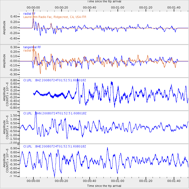
LRL Laurel Mtn Radio Fac, Ridgecrest, CA, USA - Earthquake Result Viewer
*The percent match for this event was below the threshold and hence no stack was calculated.
| Earthquake location: |
Kuril Islands |
| Earthquake latitude/longitude: |
51.0/157.6 |
| Earthquake time(UTC): |
2008/07/24 (206) 01:43:16 GMT |
| Earthquake Depth: |
27 km |
| Earthquake Magnitude: |
6.0 MB, 6.0 MS, 6.2 MW, 6.2 MW |
| Earthquake Catalog/Contributor: |
WHDF/NEIC |
|
| Network: |
CI Caltech Regional Seismic Network |
| Station: |
LRL Laurel Mtn Radio Fac, Ridgecrest, CA, USA |
| Lat/Lon: |
35.48 N/117.68 W |
| Elevation: |
1340 m |
|
| Distance: |
60.3 deg |
| Az: |
69.285 deg |
| Baz: |
313.559 deg |
| Ray Param: |
$rayparam |
*The percent match for this event was below the threshold and hence was not used in the summary stack. |
|
| Radial Match: |
49.75268 % |
| Radial Bump: |
380 |
| Transverse Match: |
62.91077 % |
| Transverse Bump: |
400 |
| SOD ConfigId: |
2504 |
| Insert Time: |
2010-02-25 20:43:00.413 +0000 |
| GWidth: |
2.5 |
| Max Bumps: |
400 |
| Tol: |
0.001 |
|
Signal To Noise
| Channel | StoN | STA | LTA |
| CI:LRL: :BHN:20080724T01:52:51.608018Z | 4.9763956 | 8.662977E-7 | 1.7408135E-7 |
| CI:LRL: :BHE:20080724T01:52:51.608018Z | 1.015959 | 3.7618412E-7 | 3.7027488E-7 |
| CI:LRL: :BHZ:20080724T01:52:51.608018Z | 4.1984015 | 4.0322124E-7 | 9.60416E-8 |
| Arrivals |
| Ps | |
| PpPs | |
| PsPs/PpSs | |


