You are here: Home > Network List > YB13 - Continental Dynamics/Cent. Anatolian Tectonics:Surface to Mantle Dynamics During Stations List
> Station AT15 Aritas,Maras,Turkey > Earthquake Result Viewer
AT15 Aritas,Maras,Turkey - Earthquake Result Viewer
| Earthquake location: |
Bonin Islands, Japan Region |
| Earthquake latitude/longitude: |
27.9/139.6 |
| Earthquake time(UTC): |
2014/09/21 (264) 17:32:05 GMT |
| Earthquake Depth: |
491 km |
| Earthquake Magnitude: |
5.5 MWW |
| Earthquake Catalog/Contributor: |
NEIC PDE/NEIC COMCAT |
|
| Network: |
YB Continental Dynamics/Cent. Anatolian Tectonics:Surface to Mantle Dynamics During |
| Station: |
AT15 Aritas,Maras,Turkey |
| Lat/Lon: |
38.35 N/36.78 E |
| Elevation: |
1422 m |
|
| Distance: |
82.3 deg |
| Az: |
309.32 deg |
| Baz: |
60.515 deg |
| Ray Param: |
0.045568734 |
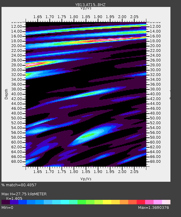
| Estimated Moho Depth: |
27.75 km |
| Estimated Crust Vp/Vs: |
1.61 |
| Assumed Crust Vp: |
6.35 km/s |
| Estimated Crust Vs: |
3.956 km/s |
| Estimated Crust Poisson's Ratio: |
0.18 |
|
| Radial Match: |
80.4857 % |
| Radial Bump: |
400 |
| Transverse Match: |
60.817215 % |
| Transverse Bump: |
400 |
| SOD ConfigId: |
3390531 |
| Insert Time: |
2019-04-14 03:59:04.956 +0000 |
| GWidth: |
2.5 |
| Max Bumps: |
400 |
| Tol: |
0.001 |
|

Signal To Noise
| Channel | StoN | STA | LTA |
| YB:AT15: :BHZ:20140921T17:43:02.700002Z | 17.12956 | 4.502742E-7 | 2.6286383E-8 |
| YB:AT15: :BHN:20140921T17:43:02.700002Z | 8.552334 | 1.7822342E-7 | 2.0839156E-8 |
| YB:AT15: :BHE:20140921T17:43:02.700002Z | 4.2916746 | 1.0352965E-7 | 2.4123368E-8 |
| Arrivals |
| Ps | 2.7 SECOND |
| PpPs | 11 SECOND |
| PsPs/PpSs | 14 SECOND |


