You are here: Home > Network List > IU - Global Seismograph Network (GSN - IRIS/USGS) Stations List
> Station RSSD Black Hills, South Dakota, USA > Earthquake Result Viewer
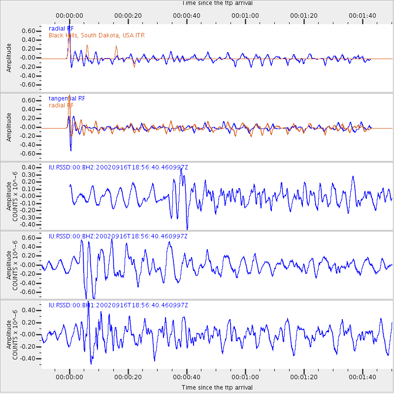
RSSD Black Hills, South Dakota, USA - Earthquake Result Viewer
*The percent match for this event was below the threshold and hence no stack was calculated.
| Earthquake location: |
Iceland Region |
| Earthquake latitude/longitude: |
66.9/-18.5 |
| Earthquake time(UTC): |
2002/09/16 (259) 18:48:26 GMT |
| Earthquake Depth: |
10 km |
| Earthquake Magnitude: |
5.5 MB, 5.7 MS, 5.8 MW, 5.8 MW |
| Earthquake Catalog/Contributor: |
WHDF/NEIC |
|
| Network: |
IU Global Seismograph Network (GSN - IRIS/USGS) |
| Station: |
RSSD Black Hills, South Dakota, USA |
| Lat/Lon: |
44.12 N/104.04 W |
| Elevation: |
2060 m |
|
| Distance: |
48.7 deg |
| Az: |
287.201 deg |
| Baz: |
31.503 deg |
| Ray Param: |
$rayparam |
*The percent match for this event was below the threshold and hence was not used in the summary stack. |
|
| Radial Match: |
63.48137 % |
| Radial Bump: |
400 |
| Transverse Match: |
67.1027 % |
| Transverse Bump: |
400 |
| SOD ConfigId: |
590571 |
| Insert Time: |
2013-09-24 23:56:44.070 +0000 |
| GWidth: |
2.5 |
| Max Bumps: |
400 |
| Tol: |
0.001 |
|
Signal To Noise
| Channel | StoN | STA | LTA |
| IU:RSSD:00:BHZ:20020916T18:56:40.460997Z | 2.6450763 | 2.3984973E-7 | 9.067781E-8 |
| IU:RSSD:00:BH1:20020916T18:56:40.460997Z | 1.1609437 | 1.2653483E-7 | 1.0899307E-7 |
| IU:RSSD:00:BH2:20020916T18:56:40.460997Z | 0.9909543 | 9.35319E-8 | 9.438569E-8 |
| Arrivals |
| Ps | |
| PpPs | |
| PsPs/PpSs | |


