You are here: Home > Network List > TA - USArray Transportable Network (new EarthScope stations) Stations List
> Station D56A ZEC Mazanza, Mont-Saint-Michel, QC, CAN > Earthquake Result Viewer
D56A ZEC Mazanza, Mont-Saint-Michel, QC, CAN - Earthquake Result Viewer
| Earthquake location: |
Near East Coast Of Honshu, Japan |
| Earthquake latitude/longitude: |
38.2/141.9 |
| Earthquake time(UTC): |
2013/08/04 (216) 03:28:50 GMT |
| Earthquake Depth: |
56 km |
| Earthquake Magnitude: |
5.8 MW, 5.8 MB, 5.9 MW |
| Earthquake Catalog/Contributor: |
NEIC PDE/NEIC PDE-W |
|
| Network: |
TA USArray Transportable Network (new EarthScope stations) |
| Station: |
D56A ZEC Mazanza, Mont-Saint-Michel, QC, CAN |
| Lat/Lon: |
47.05 N/74.76 W |
| Elevation: |
421 m |
|
| Distance: |
89.0 deg |
| Az: |
24.076 deg |
| Baz: |
331.97 deg |
| Ray Param: |
0.042060725 |
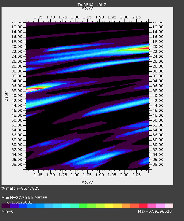
| Estimated Moho Depth: |
37.75 km |
| Estimated Crust Vp/Vs: |
1.60 |
| Assumed Crust Vp: |
6.61 km/s |
| Estimated Crust Vs: |
4.125 km/s |
| Estimated Crust Poisson's Ratio: |
0.18 |
|
| Radial Match: |
85.47825 % |
| Radial Bump: |
334 |
| Transverse Match: |
68.19618 % |
| Transverse Bump: |
400 |
| SOD ConfigId: |
589702 |
| Insert Time: |
2013-09-25 00:03:16.220 +0000 |
| GWidth: |
2.5 |
| Max Bumps: |
400 |
| Tol: |
0.001 |
|
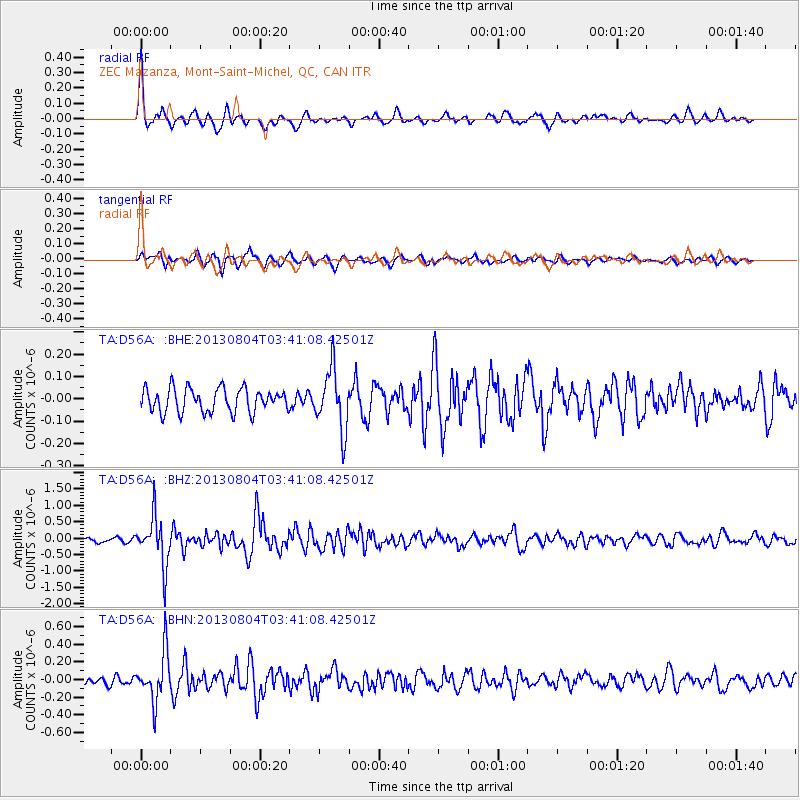
Signal To Noise
| Channel | StoN | STA | LTA |
| TA:D56A: :BHZ:20130804T03:41:08.42501Z | 11.493111 | 7.4568857E-7 | 6.4881355E-8 |
| TA:D56A: :BHN:20130804T03:41:08.42501Z | 5.8627644 | 2.8017217E-7 | 4.7788408E-8 |
| TA:D56A: :BHE:20130804T03:41:08.42501Z | 2.5445228 | 1.3487656E-7 | 5.3006623E-8 |
| Arrivals |
| Ps | 3.5 SECOND |
| PpPs | 14 SECOND |
| PsPs/PpSs | 18 SECOND |


